There is a particular kind of exhaustion that comes from living a life dictated by notifications and deadlines. It’s a mental clutter that a standard beach holiday doesn’t always fix. Sometimes, you need a journey that actually resets the system a mix of high altitude clarity and coastal grounding.
This five-day “Zen & Zest” trail is exactly that. We’re starting in the cool, misty ridges of Ella to clear the head, before dropping down to the salt-drenched shores of Ahangama to nourish the body. It’s a short trip, but if you do it right, it feels like a month of therapy.
Day 1: The Mountain Morning and the High Altitude Reset
Your journey begins in Ella. Most people come here for the hiking, but we’re here for the stillness. Check into a boutique lodge perched on the edge of the valley, somewhere like 98 Acres or a smaller, family-run eco retreat where the architecture is basically just a frame for the view.
The Morning Ritual: Sunrise over the Gap
Set your alarm for 5:30 AM. You don’t need to do a massive trek; just find a quiet spot on your veranda or a nearby ridge. As the sun starts to pull the mist out of the Ella Gap, the world goes from a moody grey to a vibrant, electric green. This is your “Zen” moment. Spend an hour just breathing it in. No phone, no plan.
The Afternoon: Forest Bathing and Tea
In the afternoon, take a slow walk through the nearby tea estates. This isn’t about “seeing a factory”; it’s about the Japanese concept of Shinrin-yoku, or forest bathing. The air here is thick with the scent of damp earth and tea blossoms. Walk until your heart rate settles. End the day with a pot of white tea, the least processed and most antioxidant-rich variety, and let the mountain’s quiet settle into your bones.
Day 2: The Yoga of the Peaks and the Slow Descent
Morning: Movement with a View
Start Day 2 with a private yoga session. There’s something about practising an asana while looking out over a 1,000-foot drop that puts your daily stresses into perspective. Whether you’re a seasoned yogi or someone who can barely touch their toes, the focus here is on the “Zest” reigniting that physical energy that gets stifled by office chairs and commutes.
Afternoon: The Scenic Transition
By midday, it’s time to head south. The drive from Ella down to the coast is a dramatic architectural shift in nature. You’ll watch the jagged mountains smooth out into rolling hills and finally into the flat, palm-fringed plains of the south. Stop at a roadside stall for a “Thambili” (king coconut). It’s nature’s electrolyte drink, and in the heat of the lowlands, it tastes like absolute heaven.
Evening: Entering the Ahangama Bubble
Arrive in Ahangama by late afternoon. This town has become the unofficial capital of “slow living” in Sri Lanka. It’s full of creative expats, surf-obsessed locals, and some of the best healthy eating spots on the island. Check into a surf and yoga retreat, the kind of place where the floors are polished concrete, and there are more plants than walls.
Day 3: The Saltwater Cure and the Surf Spirit
Today is all about the “Zest” of the ocean. Ahangama is famous for its “sticks” the iconic stilt fishermen, but it’s also home to some of the most consistent, mellow surf breaks in the country.
Morning: Finding Your Flow
Even if you’ve never touched a surfboard, take a lesson. There is no better way to get out of your head than by being dumped into the Indian Ocean. Surfing requires a specific kind of focus that leaves no room for worrying about your inbox. The salt water is a natural detox, and the sheer physical effort of paddling out will leave you feeling more alive than a dozen double espressos.
Afternoon: The Cafe Culture
After a morning in the surf, you’ll be starving. Ahangama’s food scene is built for wellness. Head to a spot like Cactus or Abode for a “Glow Bowl”, think local red rice, avocado, turmeric-stained cauliflower, and fresh grilled tuna. The architecture of these cafes is brilliant; they’re open-air, breezy, and full of people who have figured out that life is better lived at 15 kilometres per hour.
Day 4: Ancient Roots and Ayurvedic Grounding
We’ve done the movement; now it’s time for the deep recovery. Sri Lanka has a 2,000-year-old medical tradition called Ayurveda, and today it is about tapping into that.
Morning: The Consultation
Visit a local Ayurvedic pavilion. This isn’t a “spa treatment” in the Western sense. A traditional practitioner will look at your “Doshas” (your body’s elemental balance). You’ll likely be prescribed a “Shirodhara” treatment where warm, herb-infused oil is poured in a steady stream over your “third eye” (the forehead). It sounds a bit “woo woo” until you’re lying there, and your central nervous system finally decides to shut down for the first time in years. It is profoundly grounding.
Afternoon: The Herb Garden
Spend the afternoon in a local medicinal garden. Learn about the architecture of healing plants, how gotu kola boosts brain function and how turmeric fights inflammation. Understanding that the island itself is a pharmacy changes the way you look at the landscape.
Evening: Sunset Meditation
Head to a quiet stretch of beach near Kabalana. As the sun starts to dip, find a spot on the sand. You don’t need a guide or a mantra. Just sit and watch the water. The rhythmic “pulse” of the Indian Ocean is the best meditation timer there is.
Day 5: Integration and the Journey Back
On your final day, the goal is “Integration.” How do you take this Zen and Zest back to the city?
Morning: One Last Dip
Take a final swim in the ocean. The water in Ahangama is incredibly clear in the early hours. Floating on your back, looking up at the palm trees and the pale blue sky, try to “bookmark” this feeling.
Afternoon: The Final Feast
For your last meal, go truly local. Find a small “Rice and Curry” spot where they cook over wood fires. The smoky flavour of the dhal and the vibrant crunch of a gotu kola sambol is the ultimate soul food. It’s simple, honest, and perfectly balanced much like the trip itself.
The Departure
As you hit the Southern Expressway back toward Colombo or the airport, you’ll notice that your shoulders are lower and your breath is deeper. You haven’t just “seen” Sri Lanka; you’ve used its mountains and its oceans to rebuild your own internal architecture. You’re going back to the “real world,” but you’re going back with a bit more zest in your step and a lot more zen in your head.
Places to stay in Ella and Ahangama
Ella: High-Altitude Hideaways (The “Zen” Reset)
In Ella, the goal is to find accommodations that elevate you above the noise of the main town, offering panoramic views, crisp mountain air, and a sense of absolute stillness.
Eco-Luxury & Iconic Views
98 Acres Resort & Spa: The absolute benchmark for eco-luxury in the region. The chalets are built from recyclable materials and local stone, perched on a scenic tea estate. The views of Little Adam’s Peak and the Ella Gap right from the bed are unmatched.
Aarunya Nature Resort & Spa: Located slightly outside the main hub, this is a spectacular collection of luxury private pool villas set amidst tea, spice, and fruit plantations. It is the ultimate mountain sanctuary for deep relaxation.
Boutique & Heritage Stays
The Secret Ella: For a taste of old-world charm, this boutique hotel operates out of a beautifully restored planter’s bungalow. It’s nestled within a 10-acre tea estate, offering a highly personalized, quiet, and romantic atmosphere.
Hideaway Point: A smaller, highly curated boutique option that feels like a secret mountain cabin. It’s perfect for travelers who want modern, minimalist architecture that frames the lush, green surroundings.
Stylish & Social Hubs
EKHO Ella: Situated brilliantly on the edge of the mountains, this hotel offers spectacular views while keeping you within walking distance of the town’s vibrant center.
The Local Pulse: While your accommodation provides the Zen, you still need a place to connect and feel the vibrant energy of the traveler community. Cafe One Love is the ultimate anchor in Ella for this. It’s an essential stop with a brilliant, bohemian atmosphere, perfect for a post-hike cocktail or spending an evening sharing stories with fellow travelers before retreating to your quiet mountain lodge.
Ahangama: Coastal Sanctuaries (The “Zest” Reawakening)
Ahangama is less about massive resorts and more about boutique, design-forward retreats that blend surf culture, yoga, and aesthetic slow living.
Design & Wellness Havens
Palm Hotel: Set slightly inland among the jungle palms, this property is famous for its striking, black A-frame cabanas and tropical modernist design. It has an exceptional gym, a beautiful pool, and a distinct focus on active wellness.
Kurulu Bay: Located on the serene shores of nearby Koggala Lake, this luxurious retreat offers a completely different water experience. The architecture is stunning, and it features one of the most beautiful, tranquil yoga shalas in the south.
Boutique Oceanfront Stays
Harding Boutique Hotel: A masterclass in tropical modernism inspired by Geoffrey Bawa. This intimate, luxury oceanfront hotel features sweeping staircases, ocean-facing balconies, and an incredibly sophisticated coastal vibe.
Abode Boutique Hotels: Offering a few beautifully restored, aesthetic properties around Ahangama. These are perfect for travellers who appreciate vintage Sri Lankan architecture blended with contemporary, minimalist interiors.
Surf & Yoga Retreats
Dreamsea Surf Camp: Don’t let the word “camp” fool you; this is a highly stylised, bohemian beachfront property. It perfectly merges boutique comfort with a structured, community-focused surf and yoga program.
Soul & Surf Sri Lanka: Ideal for those who want a structured wellness week. They offer comprehensive packages that include daily surf lessons, yoga sessions, and holistic therapies, all run out of a beautifully designed coastal property.
The Coastal Nourishment: Your stay in Ahangama isn’t complete without the right fuel to support your surf and yoga sessions. Establishing a local base for wholesome, vibrant food is key, and COCO Kitchen is an absolute must-visit. It offers the perfect balance of fresh, locally sourced coastal dining and incredibly flavorful dishes that perfectly complement a wellness-focused itinerary.
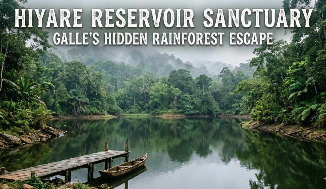
I came to Galle expecting ramparts, colonial streets, and sunsets framed by old fort walls. What I didn’t expect was to find a rainforest, quiet, misty, and alive with birdsong, just a short drive inland.
That’s how I stumbled into Hiyare Reservoir Sanctuary, a place that feels like Galle’s secret exhale. One minute you’re weaving through village roads and rubber trees, and the next you’re standing at the edge of a reservoir wrapped in rainforest, where the air smells like wet leaves and time seems to slow down on purpose.
This isn’t the Galle of postcards. This is the Galle that whispers.
First Glimpse: Where Water Meets Wild
Hiyare Reservoir Sanctuary sits on the outskirts of Galle, quietly protecting both a vital water source and a patch of lowland rainforest. The moment I arrived, the city’s noise dissolved. In its place: cicadas, distant bird calls, and the gentle lap of water against the reservoir’s edge.
The landscape felt layered—water in the foreground, forest rising behind it, mist hanging low like a half-finished thought. It was humid, yes, but also deeply refreshing. The kind of place where your shoulders drop without you noticing.
I remember thinking, How is this not more famous? And then immediately hoping it never becomes so.
What Makes Hiyare Special
Hiyare is not a national park with safari jeeps or dramatic viewpoints designed for crowds. It’s a protected sanctuary, and it feels that way. Everything here seems to move carefully, quietly, respectfully.
The area plays a crucial role in supplying water to Galle, which gives the sanctuary an added sense of importance. This forest isn’t just beautiful, it’s necessary.
It’s also a haven for biodiversity, particularly birds, butterflies, amphibians, and plant life that thrives in the damp, shaded environment.
What to See at Hiyare Reservoir Sanctuary
1. The Reservoir Itself
The reservoir is calm and reflective, often mirroring the clouds above and the trees lining its edges. Early morning light turns the surface silvery, while late afternoon brings softer blues and greens.
It’s the kind of view that encourages silence—not because you’re told to be quiet, but because it feels right.
2. Rainforest Trails
Walking through the sanctuary feels like stepping into a living encyclopedia of tropical flora. Towering trees, thick undergrowth, vines twisting like natural calligraphy, it’s lush in a way only rainforests can be.
The trails aren’t rushed or dramatic. They invite slow exploration. Every few steps, something catches your eye: a new leaf shape, a flash of colour, the sound of movement just out of sight.
3. Birdlife Everywhere
If you enjoy birdwatching—or even if you don’t know a single species by name Hiyare will convert you.
I spotted colourful kingfishers, drongos, bulbuls, and birds I couldn’t identify but deeply admired. The forest hums with life, especially in the early hours of the day.
4. Butterflies and Amphibians
Bright butterflies drift through sunlit clearings, while frogs make their presence known near waterlogged areas. After rain, the forest seems to double its activity, as if celebrating its favourite weather.
What to Do While You’re There
Slow Walks (The Best Kind)
Hiyare is not about ticking off sights, it’s about walking slowly enough to notice them. This is a place for unhurried exploration, where even a short walk feels rewarding.
Nature Photography
The light filtering through the canopy, reflections on the water, and sudden bursts of colour make Hiyare a dream for photographers. Macro lovers will especially enjoy the details of leaves, insects, and textures.
Birdwatching
Bring binoculars if you have them. If not, just listen. Sometimes identifying a bird by sound alone feels more satisfying.
Mindful Moments
I found myself sitting on a rock near the water, doing absolutely nothing and enjoying every second of it. Hiyare has a way of reminding you that stillness is also an activity.
Getting There from Katunayake International Airport
Reaching Hiyare is straightforward, and the journey offers a beautiful cross-section of Sri Lanka.
Option 1: Private Car or Taxi
This is the most comfortable way to travel from the airport to Galle. The route takes you south along the coast or via the southern expressway, depending on traffic and preference.
Once in Galle, Hiyare is just a short inland drive through quiet roads and villages.
Option 2: Train + Tuk-Tuk
For a more scenic approach:
Travel from Katunayake to Colombo Fort.
Take a southern line train to Galle.
From Galle town, hire a tuk-tuk or local vehicle to reach Hiyare.
The train journey along the coast is an experience in itself blue ocean on one side and palm trees on the other.
Option 3: Bus
Long-distance buses run from Colombo to Galle frequently. From the Galle bus terminal, Hiyare is easily accessible by tuk-tuk or local transport.
This option takes longer but immerses you in everyday Sri Lankan travel.
Where to Stay Near Hiyare
One of the best things about visiting Hiyare is that you don’t have to choose between nature and comfort—you can enjoy both.
Staying in Galle
Galle offers a wide range of boutique hotels, guesthouses, and heritage stays. Staying near the fort gives you easy access to cafes, beaches, and history, while still being close enough to escape into nature when you need it.
Eco Lodges and Retreats
Just outside the city, you’ll find eco-friendly stays nestled among trees and rice fields. These places often emphasise quiet, sustainability, and connection with nature—perfect companions to a visit to Hiyare.
Homestays
Local homestays offer warm hospitality and insights into daily life in southern Sri Lanka. Waking up to birds instead of traffic feels like an extension of the sanctuary experience.
Boutique Heritage: The Galle Fort Experience. Then, of course, there is the historic Galle Fort itself. Staying within these centuries-old ramparts is an experience in striking contrast. You trade the wild, untamed vines of Hiyare for perfectly manicured courtyards and terracotta roofs. Boutique hotels here are often restored Dutch colonial mansions, complete with thick coral walls that naturally keep the tropical heat at bay. Waking up in the Fort means stepping out onto cobblestone streets before the day-trippers arrive, grabbing a locally roasted coffee, and reflecting on the wildness that lives just a few miles inland. It’s a beautifully refined counterpoint to the reservoir’s raw, untethered nature.
Evening Exhales: The Best Pubs and Watering Holes
Galle and its surrounding coastal towns are not destinations for neon-lit, all-night raves. Much like Hiyare itself, the nightlife here is more about mood, good conversation, and slow savouring. When the sun dips below the horizon and the cicadas start their evening hum, the southern coast opens up a treasure trove of atmospheric pubs, speakeasies, and laid-back beach bars perfectly suited for winding down.
Sophisticated Sips Inside the Fort Inside the walls of Galle Fort, the evening scene is undeniably chic, often drawing heavily on the island’s rich spice-trading history.
The Archives Cocktail Bar: Located in the heart of the Fort, this spot perfectly marries historic charm with inventive mixology. It’s the kind of place where you can sit back in a warmly lit, inviting ambience with a beautifully crafted drink and discuss the day’s bird sightings.
Charlie’s Bar: If you want to taste the landscape, this is the place to be. Tucked inside The Charleston, their signature cocktails weave in local herbs, island spices, and even hibiscus foraged from local gardens. It is a brilliant way to experience Sri Lankan botany in a glass.
Ropewalk: A relatively new addition to the Fort’s scene, this speakeasy champions local Arrack, a traditional spirit distilled from coconut flower sap. With its retro charm and deep, moody lighting, it’s an excellent spot for a smooth, locally inspired nightcap.
The Laid-Back Coastal Scene If you prefer your evening drinks to come with the sound of breaking waves and a salt-rimmed breeze, heading out of the Fort and down the southern coastal road is the way to go.
COCO Kitchen (Ahangama): When you are ready to trade the quiet reverence of the rainforest for the gentle, rhythmic energy of the surf culture, make your way down to Ahangama and settle in at COCO Kitchen. This spot captures the absolute essence of southern Sri Lanka’s slow-living ethos. It boasts an incredibly welcoming, laid-back energy that immediately makes you feel like a local rather than a tourist. Whether you are stopping in for a hearty post-hike meal or lingering over cold evening drinks while swapping travel stories, the vibrant yet relaxed atmosphere here perfectly complements a day of unhurried exploration.
Unawatuna Beach Bars: For something right on the sand, the strip in Unawatuna offers numerous unpretentious spots where you can grab a cold Lion beer. Establishments like Sandbar & Grill or the lively Jungle Plaza allow you to dig your toes into the sand, watch the tide roll in, and let the day slowly fade away under a canopy of stars.
Crafting the Perfect Balance
What makes this corner of Sri Lanka so remarkable is the proximity of these contrasting experiences. You don’t have to be a hardcore trekker to enjoy the rainforest, just as you don’t have to be a surfer to appreciate the coastal bars.
The magic lies in the pairing. Imagine starting your day at dawn, driving up the winding roads to Hiyare. You spend the morning in the quiet company of kingfishers and drifting butterflies, breathing in the dense, oxygen-rich air of the sanctuary. By early afternoon, you’ve descended back to the coast, washing off the humidity in the Indian Ocean before retreating to a breezy coastal lodge. And as evening falls, you find yourself with a spiced craft cocktail in hand inside a 300-year-old fort, or laughing over incredible food and drinks in Ahangama, the salt air mixing with the scent of roasted local spices.
When to Visit Hiyare
Mornings are magical here. The forest feels fresh, birds are active, and the air is cooler. After rainfall, the sanctuary comes alive, everything greener, louder, and more vibrant.
That said, Hiyare has a moody charm even on overcast days. Mist clings to the trees, and the forest feels deeper, more mysterious.
Wear comfortable walking shoes, bring water, and be prepared for humidity; it’s all part of the rainforest deal.
Pairing Hiyare with Other Experiences
One of the joys of visiting Hiyare is how easily it fits into a broader Galle itinerary.
You can:
Explore Galle Fort in the morning.
Visit Hiyare Reservoir Sanctuary in the afternoon.
End the day watching the sun set over the ocean.
Few places offer that kind of contrast in a single day.
Why Hiyare Stayed With Me
Some destinations demand your attention with grandeur.
Others earn it through quiet persistence.
Hiyare did the latter.
It didn’t overwhelm me with views or thrill me with adventure. Instead, it gently reminded me how good it feels to walk under trees, listen to birds, and exist without an agenda.
As I left the sanctuary, stepping back into the hum of Galle’s streets, I felt like I was carrying a little piece of rainforest calm with me.
If you’re travelling through southern Sri Lanka and craving a pause, a place where nature leads, and humans follow, Hiyare Reservoir Sanctuary is waiting, quietly, just beyond the city’s edge
Some places call you softly like a whisper from behind the mist. Kotmale is one of them.
Tucked deep in Sri Lanka’s central highlands, this region is often overshadowed by its more famous neighbours: Nuwara Eliya, Kandy, Hatton. Travelers rush past it on winding roads, unaware that they are bypassing a valley of legends, secrets, and staggering natural beauty.
But the mist has a funny way of revealing treasures only to those willing to wander a little slower. And that’s exactly how Kotmale found me slowly, gently, unexpectedly.
This is the story of my journey through Kotmale: a quiet world of hidden cascades, ancient temples swallowed by time, and a reservoir that reflects the sky like a giant silver mirror.
Getting to Kotmale from Katunayake Airport
When I landed at Katunayake Bandaranaike International Airport, the air smelled of heat and lotus ponds. Kotmale, nestled deep in the uplands, couldn’t be more different—but that contrast is what makes the trip so rewarding.
Here’s how you can get there:
• Private vehicle:
The most comfortable option. The route takes you from the coastal plains and inland through Kegalle, then up winding hill roads toward Gampola and finally Kotmale. Expect lush scenery, roadside fruit stalls, and a steady change in temperature as you rise into the mountains.
• Train:
From the airport, you can head to Colombo Fort Railway Station. From there, catch a train to Gampola or Nawalapitiya. The highland train ride is a dream—tea estates, river crossings, valleys wrapped in mist. From the station, a tuk-tuk or taxi will take you into Kotmale.
• Bus:
You can take a bus to Kandy or Gampola and then change buses toward Kotmale. It’s longer but a great way to see everyday Sri Lankan life in motion.
No matter the route, the final stretch of the journey through steep curves, mossy stone walls, and towering jak trees—feels like entering a secret world.
First Impressions: Mist, Mountains, Magic
Kotmale greeted me with the smell of wet earth.
My breath fogged in the evening air as I stepped out of the vehicle. Clouds drifted lazily between the hills, thick and low enough to touch, and the valley far below shimmered with the faint glow of village lights. Somewhere in the distance, I heard the faint rush of a waterfall—one of the many hidden gems of this region.
This wasn’t the polished charm of Nuwara Eliya nor the urban buzz of Kandy. Kotmale felt authentic, secluded, and intensely alive.
What to See and Do in Kotmale
Kotmale is not one attraction it is a constellation of small wonders scattered across mountainsides, along rivers, and inside forgotten corners of jungle. Here are the experiences that shaped my journey:
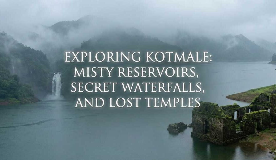
1. Visit the Kotmale Reservoir
Imagine a lake so still it mirrors the sky perfectly. Now imagine that lake surrounded by towering mountains wrapped in mist. That is the Kotmale Reservoir.
Built as part of a major hydroelectric project, the reservoir swallowed entire villages beneath its depths but the surface today is calm, beautiful, and almost ethereal.
I visited the dam early in the morning. The water was a sheet of silver, the mountains hovered like sleeping giants, and fishermen glided across the surface in narrow wooden boats. The quiet here is almost meditative.
Best experiences at the reservoir:
Standing on the dam at sunrise
Taking photos of the calm waters
Watching mist move across the lake like drifting cotton
2. Climb Up to the Mahaweli Maha Seya
A massive white stupa rising against the mountains—this is the Mahaweli Maha Seya, a structure built to honor the submerged temples and villages lost under the Kotmale reservoir.
Climbing up the long, winding road felt like a pilgrimage. Monkeys watched from the treetops, birds chattered endlessly, and the breeze carried the scent of temple flowers.
From the top, the view was breathtaking. Green valleys, patches of tea estate, the reservoir glistening in the distance it felt like looking down at a map painted with emerald and silver.
3. Explore Lush Green Tea Plantations
Kotmale tea doesn’t always get the same spotlight as Nuwara Eliya or Uva, but don’t let that fool you; the plantations here are gorgeous.
I walked through one estate at golden hour. Rows of tea bushes curved along the hills like soft green waves. Women in bright saris moved between the plants with baskets on their backs, chatting, laughing, singing. A cool wind whispered through the leaves.
Some estates offer little tea-tasting corners where you can sip a steaming cup while watching the landscape change colours with the sinking sun.
4. Discover Secret Waterfalls
Kotmale is full of waterfalls that feel like they belong in fairy tales. Some are well-known, others are hidden behind rural paths and moss-covered stones.
Waterfalls worth exploring include:
Kadadora Temple Waterfall – a small cascade near the submerged temple ruins.
Dunsinane Falls – tall, majestic, and framed by massive rocks.
Kotmale Oya Falls – flowing along the river that feeds the reservoir.
Kadiyanlena Falls (a short drive away) – a three-tiered beauty visited by few.
My favourite? A tiny, unnamed fall I stumbled upon while following what I thought was a shortcut. The water spilled down in a delicate curtain, surrounded by ferns and singing cicadas. I sat on a rock, feet dipped in the cool stream, feeling like an explorer who had just uncovered a secret.
5. Search for the Lost Kadadora Temple
This one gave me goosebumps.
Before the reservoir was built, villages and temples were scattered across these valleys. When the water rose, many structures sank beneath its surface. But during the dry season, something extraordinary happens—the top of Kadadora Temple occasionally emerges like a ghost from the past.
When I visited, the water level was high, but I could see the edges of stone walls peeking out near the shore. Locals told me stories about how the entire village used to stand there—houses, kovils, paddy fields, footpaths.
It is haunting. Beautiful. Tragic. And absolutely worth visiting.
6. Visit the Kotmale Hanging Bridge
An old-style suspension bridge stretches across a river outside the main town. With wooden planks and swaying cables, it feels like a bridge from another era.
I walked slowly across it, the water rushing below me, the bridge gently bouncing with each step. On the other side, children splashed in the river, calling out to each other in Sinhala, their voices echoing across the valley.
7. Stroll Through Rural Villages
Don’t underestimate the charm of Kotmale’s village life.
One morning, I walked along a small winding lane lined with jackfruit trees, home gardens, and rice paddies. Elderly women offered me fresh guavas. A man invited me to see his spice garden. Dogs followed me like loyal companions. Everywhere, people smiled.
The heart of Kotmale isn’t its attractions, it’s its people.
Where to Stay in Kotmale
Kotmale stays are typically small-scale, cozy, and perched on hillsides with sweeping valley views. You won’t find big resorts here, and that’s the beauty of it.
Expect charming guesthouses, hillside lodges, and homestays where:
Rooms open into mist.
Breakfasts smell like milk, rice and curries.
You wake to bird calls instead of alarms.
The hosts treat you like family.
Look for places near:
Kotmale Reservoir
Kadadora area
Gampola-Kotmale road
Rural hilltop communities with great views
I stayed in a homestay overlooking the reservoir. Every morning, mist rolled across the water like a living creature. Every night, the sky filled with stars so bright it felt like someone switched off the world.
What to Eat
Kotmale food is the kind that comforts your soul.
Must-try dishes:
Traditional hill-country rice and curry.
Freshly prepared rotti with lunu miris.
Homemade kiri bath (milk rice).
Tea straight from the plantation leaves.
Local herbal porridge.
Fried freshwater fish caught from the reservoir.
One lovely auntie served me jackfruit curry that nearly made me cry because it tasted exactly like my grandmother’s. That’s Kotmale for you food made with love, patience, and recipes handed down for generations.
Why Kotmale Refuses to Leave Your Heart
Kotmale is not a place you “sightsee.” It’s a place you feel.
It’s the valley fog creeping under your balcony.
It’s the white stupa rising like a moon on the hillside.
It’s waterfalls humming ancient lullabies.
It’s temple ruins sleeping beneath dark water.
It’s tea leaves glistening in morning dew.
It’s villagers with warm smiles and stories older than the reservoir itself.
On my last morning, I walked down to a quiet viewpoint overlooking the Kotmale Oya. Mist curled around the riverbanks. A kingfisher swooped across the water, blue wings flashing. Somewhere in the distance, temple bells rang.
I stood there a long time. Breathing. Watching. Listening.
Kotmale doesn’t dazzle you with grandeur.
It seduces you softly with silence, with stories, with serenity.
And when you leave, it quietly slips into your heart and stays there, like mist that never quite lifts.
If you long for a destination that blends mystery, nature, history, and stillness… Kotmale is waiting.
Most people meet Hanthana from a viewpoint. They arrive mid-morning, climb a well-worn path just outside Kandy, take in the famous rolling hills, snap a few photos, and leave thinking they’ve “done” it.
I thought the same—until I stayed longer, walked farther, and slipped past the familiar paths into the quieter folds of the range. That’s when Hanthana changed entirely.
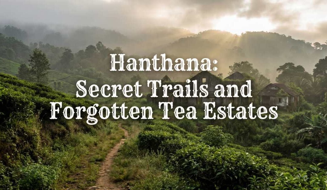
Beyond the popular trails lies a landscape shaped by forgotten tea estates, half-swallowed bungalows, misty ridgelines, and paths used more by estate workers than weekend hikers. Hanthana after the crowds is slower, subtler, and far more intimate. It’s not about conquering a peak—it’s about wandering through a living, breathing chapter of Sri Lanka’s hill-country story.
First Morning in Hanthana: When the Hills Are Still Asleep
I woke before dawn to the sound of wind brushing tea leaves together a soft, collective sigh rolling across the slopes. From my window, the hills looked unfinished; edges blurred by mist, valleys holding onto the night just a little longer.
This is the hour Hanthana belongs to itself. By sunrise, the popular trails begin to stir. But earlier than that, the hills feel untouched, as if you’ve arrived before the world remembers you’re there. That’s when the hidden Hanthana reveals itself.
A Landscape Written in Tea and Time
Hanthana isn’t “wild” in the traditional sense. It’s cultivated, shaped by colonial ambition and generations of labor. Tea bushes trace the contours of the hills like handwriting. Stone steps appear suddenly, leading nowhere obvious. Old cart paths cut through grass, once busy with workers and horses, now quiet except for birds.
The beauty here isn’t dramatic—it’s cumulative. Every turn holds a reminder that these hills have been worked, lived in, and slowly reclaimed by nature.
What to See: Beyond the Usual Viewpoints
While most visitors cluster around the first two peaks, the true spirit of Hanthana is found in its neglected corners.
1. The Seven Peaks: A Test of Endurance
Most hikers stop at the second peak, satisfied with the view of Kandy. However, the Hanthana range consists of seven distinct peaks.
The Transition: As you move toward the fourth and fifth peaks, the path narrows significantly. The grass grows waist-high (often called “Mana” grass), and the wind picks up.
The Reward: By the time you reach the seventh peak, the urban sprawl of Kandy is long gone, replaced by a 360-degree panorama of the Laggala mountains and the Knuckles Range in the distance.
2. The Ceylon Tea Museum (The Old Hanthana Factory)
Housed in the 1925-built Hanthana Tea Factory, this museum is often bypassed by those racing for the summit. It is a cathedral of industrial history.
The Machinery: You can see the original Wilken’s tea rollers and ancient drying fans.
The Scent: The building still smells faintly of fermented tea leaves and old wood—a scent that defines the region’s DNA.
3. The Forgotten Uduwela Loop
If you follow the Uduwela Road rather than the main hiking trailhead, you enter a world of “forgotten” Hanthana.
Abandoned Bungalows: You’ll find colonial-era structures with sagging roofs and gardens where roses still bloom amidst the weeds.
Small Kovils: Tucked into the tea bushes are tiny, brightly colored Hindu shrines (Kovils) where estate workers leave fresh flowers. These are the spiritual anchors of the hills.
4. The University “Backdoor”
The upper reaches of the University of Peradeniya bleed directly into the Hanthana range. This area is a sanctuary for biodiversity.
The Pine Forests: Lower down, you’ll find sections of pine forest where the ground is a soft carpet of needles—a sharp contrast to the jagged rocks of the peaks.
What to Do: The Art of Slow Exploration
Hanthana rewards those who trade their “summit fever” for a sense of curiosity.
1. Birdwatching in the Mist
Hanthana is an overlooked birding hotspot. Because it sits between the lowland and the high montane forests, you get a mix of species.
What to look for: Keep an eye out for the Yellow-fronted Barbet, the Sri Lanka Hanging Parrot, and the elusive Red-faced Malkoha.
The Experience: Bring binoculars and wait near the edge of a forest patch at 6:30 AM. The symphony of calls as the mist lifts is worth the early wake-up call.
2. The “Pol Rotti” Ritual
Near the trailheads and along the estate roads, you’ll find small wooden kiosks.
The Order: Ask for Pol Rotti (coconut flatbread) with Lunu Miris (an onion and chili paste) and a hot ginger tea.
The Vibe: Sitting on a wooden bench, watching the mist roll over the tea bushes while eating spicy rotti, is perhaps the most “authentic” Hanthana experience you can have.
3. Photography: Capturing the “Negative Space”
Most people take wide landscape shots. Instead, try focusing on the details:
The way a single dewdrop hangs from a tea bud.
The weathered hands of an estate worker.
The textures of the moss-covered stone boundary markers from the 1800s.
4. Night Camping (With Caution)
For those who want to see the stars without the light pollution of Kandy, some spots on the lower ridges allow for camping.
A Note on Safety: Always check local weather reports. Hanthana is notorious for sudden “mountain mists” that can reduce visibility to zero in minutes.
A Comparison of Hanthana Routes
Route
Difficulty
Highlight
Crowds
Main Trail (Peaks 1-2)
Moderate
Classic View of Kandy
High
The Full Seven Peaks
Hard
True Wilderness Feel
Very Low
Tea Museum Loop
Easy
Industrial History
Moderate
Uduwela Estate Road
Easy/Moderate
Abandoned Bungalows
Rare
Where to Stay: Finding Your Base
Staying in the range is the only way to catch the blue hour—that magical time just before sunrise when the hills are indigo.
Estate-Style Lodgings: Look for converted “Assistant Superintendent” bungalows. They offer high ceilings, teak furniture, and the silence of a bygone era.
Homestays in Uduwela: These offer a chance to eat home-cooked Sri Lankan meals. You haven’t lived until you’ve had Hanthana-grown pepper in a chicken curry.
The Peradeniya Edge: Staying near the university allows you to walk up through the campus and into the hills, combining academic architecture with natural beauty.
How to Get There: Navigating the Slopes
Hanthana’s accessibility is part of its charm—it’s close enough to reach easily, yet distant enough to feel removed.
By Car/Tuk-Tuk: From Kandy city center, take the Hanthana Road past the General Hospital. The climb starts almost immediately. A tuk-tuk is actually better than a car for the narrower estate tracks.
By Train: Take the train to Sarasavi Uyana station (near the university). From there, it’s a steep but beautiful uphill hike.
The “Secret” Route: Enter through the Galaha Road side. It’s a longer drive from Kandy, but it takes you through some of the most pristine tea patches in the region.
The Practicalities: Leeches, Weather, and Gear
Let’s be candid: Hanthana is beautiful, but it can be prickly.
The Leech Factor: If it has rained recently, the leeches will be out. They aren’t dangerous, just ambitious. Wear long socks and carry a small pouch of salt or “leech balm.”
Hydration: There are no shops once you pass the initial tea estates. Carry at least 2 litres of water.
Footwear: The “Mana” grass can be slippery, and the rocks are often loose. Trail shoes or hiking boots with good grip are non-negotiable.
Weather: It can be 30°C in Kandy and 18°C on the Hanthana ridges. Bring a light windbreaker.
Walking Respectfully: An Ethical Note
These hills are not a theme park—they are a workplace and a home.
The Pluckers: The women you see picking tea are working a gruelling job. Don’t thrust a camera in their faces without asking. A simple “Ayubowan” (May you live long) and a smile usually open doors to a brief, friendly exchange.
Waste: There is no trash collection on the peaks. If you bring a plastic bottle up, you must bring it down. The Hanthana watershed provides water to thousands of people below; keep it clean.
Private Property: Some bungalows are private residences. Respect the gates and fences.
Why Hanthana Matters
Travel often encourages us to move fast, see more, and check things off. Hanthana, after the crowd,s quietly resists that impulse.
It asks you to notice details instead of highlights. It asks you to walk without announcing your presence. It teaches you that the “best” view isn’t always the one on the postcard; sometimes, it’s the view of a mist-covered valley through the rusted frame of a forgotten estate gate.
As I left Hanthana, walking down one of those old stone paths with mist curling around my ankles, I realized I hadn’t taken many photos. Not because there wasn’t beauty, but because I didn’t want to interrupt it.
Hanthana, when you meet it on its own terms, doesn’t feel like a destination. It feels like a pause. A long, deep breath between the noise of the places we’re told to see and the quieter landscapes that choose us instead. And once you’ve walked these secret trails, the crowded viewpoints will never quite satisfy you again.
I arrived in Meemure the way most people do: dusty, slightly disoriented, and with the faint suspicion that Google Maps had finally decided to prank me. The road narrowed into a suggestion rather than a promise, the signal vanished, and the mountains of the Knuckles Range rose like a quiet warning: you’re not in charge here anymore.
That, I would soon learn, is Rule Number One of village hospitality in Sri Lanka: arrive humble.
Meemure isn’t the kind of place you “visit.” You are received. The village doesn’t roll out welcome signs or glossy brochures. Instead, it watches you first. From doorways. From paddy fields. From the edges of footpaths where barefoot children pause mid-game to decide whether you’re interesting or just another confused outsider.
By the time I reached the village centre, if you can call a cluster of homes, a temple, and a school a “centre”, I had already broken into a sweat and a smile. A man sitting on a wooden bench nodded at me. Not a greeting, not a question. Just a nod. I nodded back. Another rule unlocked: don’t overdo it. Enthusiasm is fine. Loud enthusiasm is suspicious.
I had barely put my bag down before the first offer came.
“Tea?”
In Meemure, tea is not a beverage. It is a declaration of intent. Saying no is theoretically possible, in the same way it’s theoretically possible to swim upstream during a monsoon.
The tea arrived strong and sweet, accompanied by something fried, something steamed, and something that looked like it had been invented specifically to test my willpower. I hadn’t asked what any of it was. That’s Rule Three: don’t interrogate the food like it’s a crime suspect.
Village hospitality doesn’t ask about your diet preferences, your allergies, or your relationship with carbs. It operates on a simpler belief system: If you are here, you must eat. Food is how villagers say hello, how they say stay, and how they say you’re safe now.
Later, I’d learn that every house I passed had quietly discussed whether I had eaten enough. Not eaten at all—enough. Portions are watched with concern. Seconds are encouraged with enthusiasm. Third helpings are met with satisfied smiles.
At some point, I wandered toward the kitchen area, curious about the orchestra of smells. Immediately, a gentle protest arose.
“No, no, sit.”
This wasn’t exclusion. It was respect. The kitchen is where magic happens, where generations of muscle memory guide hands that don’t need measuring cups or timers. But if you linger long enough, curiosity outweighs protocol. You’ll be handed a coconut scraper, or asked to hold something, or simply allowed to watch.
And if you praise the food—even clumsily—you will be remembered forever.
Village conversations don’t start with questions like What do you do? They start with the weather, crops, last night’s rain, or whether the river is behaving itself.
In Meemure, time stretches. People talk in pauses. Silence isn’t awkward; it’s punctuation. I sat on a verandah one evening, watching mist roll down the hills, and realised no one was trying to “entertain” me. That was another rule: you are not the guest of honour—you are part of the background now.
Eventually, stories emerge. About elephants wandering too close. About a child who moved to the city. About how things used to be when the road was worse, the nights darker, and life somehow simpler and harder at the same time.
You listen more than you speak. And when you do speak, you keep it honest. Villages have a finely tuned radar for nonsense.
Shoes come off often in Meemure. At doorsteps. Near temples. Sometimes, just because it feels right. No one announces it. You notice by watching feet.
This extends beyond footwear. Respect is shown in posture, in tone, in the way you accept what’s offered without acting like it’s exotic or strange. Taking photos without asking feels wrong here, even if no one stops you. Another unwritten rule: if it feels like you should ask, you should ask.
When permission is given, it’s wholehearted. Smiles widen. People straighten their sarongs, brushtheir hair back, and call others into the frame. Hospitality, once unlocked, becomes generous to the point of embarrassment.
I woke up early on my first morning to the sound of roosters arguing with the concept of dawn. Mist clung to everything. Somewhere, a radio played softly. Someone was already sweeping the yard with a handmade broom, the rhythm steady and meditative.
No one sleeps in late in a village unless they’re sick or very old. The day begins with purpose. Cows are tended to. Fields are checked. Water is fetched. Even breakfast feels like a checkpoint rather than a destination.
As a visitor, you’re not expected to work—but you’re expected to notice. To appreciate that life here is shaped by daylight and seasons, not notifications. That awareness, I realised, is another form of respect.
One evening, after sitting and talking long past sunset, I stood up to leave.
“Wait,” someone said.
A lantern appeared. Then another person. Then a child, inexplicably holding a stick as if it were a ceremonial guard duty. I tried to protest. Laughed it off. That didn’t work.
Walking someone home is not about safety alone. It’s about care. About closing the loop. About making sure the day ends properly. Even if your place is visible from where you’re standing, someone will walk with you until the goodbye feels complete.
Village hospitality isn’t transactional. No one expects anything from you. Which somehow makes the smallest offering feel enormous.
On my last day in Meemure, I was handed a bag of homegrown produce. No speech. No explanation. Just a casual “for the road.”
Refusing would have been rude. Making a big deal out of it would have been worse. The correct response, I learned, is gratitude without performance. A smile. A thank you. And the promise spoken or unspoken that you’ll remember.
When I finally left Meemure, the village didn’t wave goodbye dramatically. Life continued. Someone swept a yard. Someone called out to a neighbour. The mountains stayed exactly where they were.
But I carried something with me that wasn’t in my bag.
Village hospitality in Sri Lanka doesn’t try to impress you. It doesn’t sell itself. It simply opens a door and trusts you to behave like a decent human once you’re inside.
The rules are unwritten because they don’t need to be written. You feel them. You learn them by watching, by listening, by being gently corrected when you get it wrong.
And long after the dust has settled on your clothes and the road has widened again, you realise the real gift wasn’t the food, or the walks, or the tea.
It was the quiet lesson that hospitality, at its best, isn’t about hosting at all.
It’s about belonging, even if only for a little while.