by Travel Nomad | Apr 5, 2026 | Southeast Asia, Sri Lanka |
I didn’t come here looking for ruins. I came looking for water.
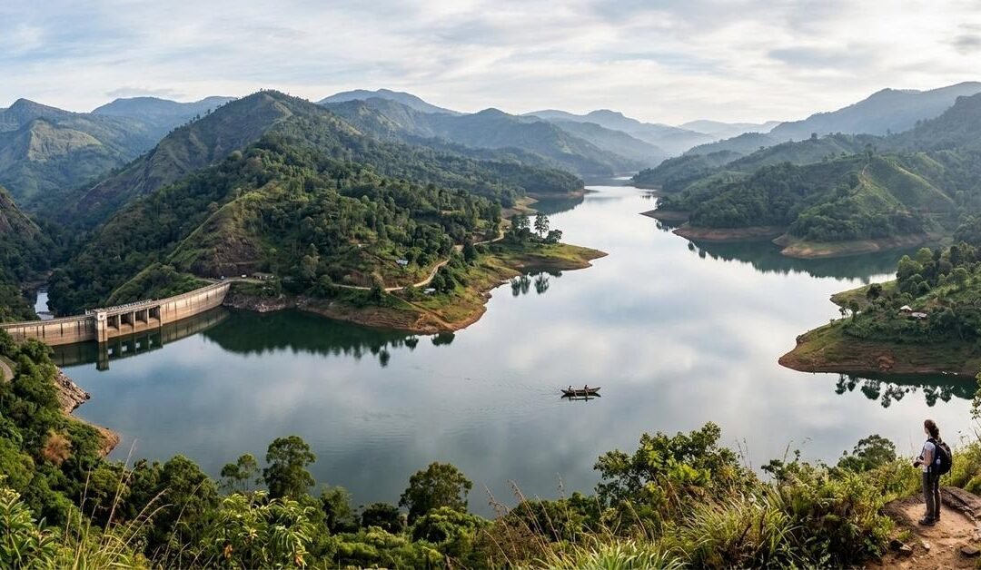
From photos alone, Rantembe and Randenigala appear calm, almost meditative—two vast reservoirs folded neatly into Sri Lanka’s hill country, reflecting clouds like they’ve got nothing to hide. It’s only when you stand at their edges, watching the surface hold its breath, that you realize these waters are not just scenic. They are full. Not only of rain and river, but of memory.
These reservoirs didn’t simply reshape landscapes. They erased villages.
Following the Mahaweli Into the Hills
The journey inland feels like slipping behind the scenes of Sri Lanka.
Leaving the western plains behind, the road climbs steadily toward Kandy, then continues eastward toward Mahiyanganaya. The air changes. The crowds thin. The land begins to speak more quietly.
The Mahaweli River appears in fragments at first—glimpses between bends, flashes of silver through forest—before finally surrendering itself to concrete and engineering. Rantembe comes first, upstream and restrained. Randenigala follows downstream, wide and commanding, a body of water that demands you stop the vehicle and step out just to absorb it.
From above, the reservoirs curve through drowned valleys, their fingers reaching into places that were once paths, gardens, and school routes.
What Lies Beneath the Surface
Locals don’t speak about the reservoirs dramatically. They don’t need to.
Someone will point toward a quiet stretch of water and say, “There was a temple there.” Another will mention a market that used to sit where the water now deepens. The tone is neutral, almost practical, as if memory has learned to coexist with inevitability.
When the dams were built as part of the Mahaweli Development Scheme, entire communities were relocated. Houses were dismantled. Temples were moved where possible. Some things were taken carefully. Others were left to the water.
On rare days when water levels recede, the past briefly returns—stone steps, foundations, lines that hint at former lives. Then the water rises again, and the land forgets in its own way.
What to See: Scale, Silence, and Light
The dams themselves are worth pausing at—not because they are beautiful in a traditional sense, but because they are uncompromising.
Randenigala Dam, especially, stretches across the valley with quiet authority. Standing there, you feel both impressed and unsettled. Human ambition made physical.
Beyond the structures, the real spectacle is the water meeting the hills. Early mornings bring mist that softens everything. By afternoon, the reservoirs shine harsh and metallic. Evenings turn them into mirrors tinted with orange and violet.
Viewpoints along the access roads offer long, uninterrupted looks across the water. These are not places for quick photos. They’re places where you sit longer than planned.
Things to Do: Observe, Walk, Listen
This is not a destination that overwhelms you with activities.
The best thing to do here is to move slowly. Walk sections of the reservoir edge where access allows. Watch local fishermen work with practiced patience. Notice how birdlife gathers where water and forest meet—eagles overhead, herons unmoving, kingfishers striking suddenly.
Photography rewards waiting rather than wandering. The reservoirs change mood constantly, and the best moments arrive unannounced.
If you’re open to conversation, speak with people who lived through the transition. Their stories are rarely rehearsed, but they stay with you far longer than any viewpoint.
Wildlife Along the New Shorelines
Where villages once stood, ecosystems have adapted.
The reservoirs attract birds in impressive numbers, especially during quieter hours. Monkeys patrol the trees, alert and curious. Deer sometimes appear near the edges, cautious but present.
Nature adjusts quickly. Human memory takes longer.
Where to Stay: Quiet Hills Over Waterfront Views
Accommodation around Rantembe and Randenigala is spread across the surrounding hills rather than clustered at the water.
Small guesthouses, eco-lodges, and homestays are scattered through nearby villages and hill towns. Staying higher up offers broader views and cooler evenings, along with easier access to main roads.
Some travelers choose bases near Mahiyanganaya, combining reservoir visits with nearby cultural and natural sites. Others prefer staying closer to the hills, where mornings begin with mist and end in deep quiet.
Wherever you stay, expect early nights and very dark skies.
How to Get There from Katunayake Airport
Reaching Rantembe and Randenigala requires distance, not difficulty.
From Katunayake Airport, traveling by private vehicle is the most direct option. The route heads toward Kandy and then onward to Mahiyanganaya, from where smaller roads branch toward the reservoirs.
Public transport works with flexibility. Buses run frequently from Colombo to Kandy and Mahiyanganaya. From Mahiyanganaya, local buses or tuk-tuks continue toward Rantembe and Randenigala, though timing depends more on rhythm than schedule.
Trains can take you as far as Kandy. From there, road travel completes the journey through increasingly scenic terrain.
The final stretches are narrow and winding. Give them the time they deserve.
When to Visit: Let the Water Decide
The reservoirs tell different stories depending on the season.
When water levels are high, the landscape feels endless and serene. When levels drop, shorelines stretch outward and textures emerge, making it easier to imagine what once existed.
Early mornings offer mist and stillness. Late afternoons bring dramatic light and long reflections. Midday is better spent resting, observing from shade.
Weather in the hills changes quickly, so adaptability matters more than planning.
What These Places Make You Think About
Rantembe and Randenigala don’t fit neatly into the idea of a tourist attraction.
They are beautiful, undeniably so. But they also carry weight—the kind that doesn’t announce itself. Standing there, I thought about electricity flowing invisibly into cities, irrigation channels feeding distant fields, and the quiet sacrifices that made it possible.
There are no dramatic memorials marking what was lost. Just water, holding everything evenly.
Life continues around it. Children grow up knowing only the reservoirs, not the villages beneath them. Memory fades, but not completely.
Leaving With a Different Kind of Memory
When I left, I didn’t feel energized the way I do after beaches or mountains. I felt thoughtful.
Rantembe and Randenigala are not places you conquer or consume. They are places you sit with.
Not every destination is meant to entertain.
Some exist to remind you that landscapes have histories, and progress always leaves something behind.
These reservoirs hold water.
And beneath that, they hold lives.
by Travel Nomad | Apr 2, 2026 | Southeast Asia, Sri Lanka |
There’s a point in every Sri Lanka journey when the roads thin out, the crowds vanish, and the ocean starts to feel like it belongs only to you. For me, that moment arrived somewhere past the last busy junction, when the tarmac gave way to dust, salt hung in the air, and the Indian Ocean appeared—wild, empty, and unapologetically untamed.
This is Panama and Okanda, two remote coastal villages on Sri Lanka’s east coast that don’t beg for attention. They don’t advertise themselves with beach clubs or neon signs. They simply exist—quiet, sunburnt, and breathtakingly raw.
If Sri Lanka’s south coast is a polished postcard, Panama and Okanda are the pages of a travel journal that still smell like sea spray.
First Impressions: Where the Map Feels Optional
Panama sits just south of the more familiar surf town of Arugam Bay, while Okanda lies even further south, skirting the edge of Yala East National Park. This stretch of coastline feels like the country exhaling after holding its breath.
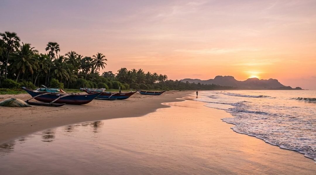
The beaches are long and uninterrupted. Fishing boats rest on the sand like they’ve been paused mid-story. Palmyrah trees lean toward the sea. And the silence—broken only by waves and wind—feels deliberate.
I remember standing on the shore at Okanda at sunrise, realizing there were no footprints in the sand except my own. No vendors. No music. Just ocean, sky, and time moving slowly.
Panama Beach: Laid-Back, Local, and Beautifully Unpolished
Panama village has a gentle rhythm. It’s not sleepy—it’s simply unhurried.
What to See in Panama
Panama Beach
Wide, sandy, and often empty, this beach feels personal. The waves roll in with confidence, and the shoreline stretches far enough that walking it feels meditative.
Lagoon Backdrops
Just inland, you’ll find lagoons and wetlands reflecting the sky, especially stunning in the early morning when birds rule the airspace.
Fishing Life
Watching fishermen bring in their catch at dawn is its own quiet spectacle. No performance, no audience—just daily life continuing as it always has.
What to Do in Panama
Surf Without the Scene
The waves here attract surfers who prefer solitude over surf schools. It’s surfing stripped back to its essentials.
Beach Walks That Go Nowhere (In the Best Way)
No destinations, no checkpoints—just walk until you feel like turning around.
Stargazing
With almost no light pollution, nights here reveal a sky that feels impossibly large.
Okanda: Where the Road Ends and the Wild Begins
Okanda feels like the edge of something—civilization, perhaps, or routine.
This is a place shaped by pilgrimage, wilderness, and the ocean. It’s also one of the last coastal villages before the landscape becomes deeply untamed.
What Makes Okanda Special
Okanda Murugan Temple
A sacred site for pilgrims traveling on foot along the coast. The temple adds a spiritual gravity to the area, especially during early morning prayers.
Proximity to Yala East
Okanda sits near the boundary of Yala’s lesser-visited eastern side. Elephants, peacocks, and deer don’t respect invisible borders—and that’s part of the magic.
Endless, Empty Beach
This is the kind of beach where you instinctively lower your voice. Not out of fear—but respect.
What to Do in Okanda
Sunrise Watching
The sun rises directly over the ocean here, painting the sky in colors that feel unreal.
Quiet Exploration
Wander the village paths, observe daily life, and let curiosity—not itineraries—lead.
Disconnect Completely
Okanda isn’t interested in constant connectivity. And after a day here, neither was I.
Getting There from Katunayake International Airport
Reaching Panama and Okanda is part of the experience. This isn’t a hop-on, hop-off destination—and that’s exactly why it remains special.
Option 1: Private Car or Taxi
From the airport, the journey takes you across the island—from the west coast, through central landscapes, and down toward the east. It’s the most comfortable and flexible option, especially if you want to stop along the way.
The scenery changes dramatically as you travel—urban sprawl fades into paddy fields, then forests, then open coastal plains.
Option 2: Train + Road Combo
Travel from the airport to Colombo Fort
Take a train toward Batticaloa or Ella
From a major stop like Monaragala or Pottuvil, continue by tuk-tuk or local vehicle
This option is slower but deeply rewarding, offering a window into everyday Sri Lankan life.
Option 3: Bus for the Adventurous
Long-distance buses run from Colombo toward Pottuvil and Panama. From Panama, Okanda is accessible via rugged coastal roads, best navigated by tuk-tuk or 4WD vehicles.
Expect dust, bumps, and unforgettable views.
Where to Stay: Simple, Comfortable, and Close to Nature
Accommodation in Panama and Okanda reflects the spirit of the place—low-key and thoughtfully minimal.
Panama Stays
Eco Lodges tucked among trees, offering open spaces and ocean sounds as your alarm clock
Small Guesthouses run by local families, where evenings often end with shared stories and home-cooked meals
Okanda Stays
Basic Beach Cabins designed for travelers who value location over luxury
Nature Retreats near the forest edge, where wildlife sightings aren’t scheduled—they just happen
If you prefer more amenities, nearby Arugam Bay offers additional options while still allowing easy day trips south.
What to Pack (and What to Leave Behind)
Bring:
Light clothing for heat and humidity.
A good hat and sunscreen.
Reusable water bottle.
Curiosity and patience.
Leave behind:
Rigid schedules.
Expectations of nightlife.
The need to always be “doing something”.
These beaches reward stillness.
Best Time to Visit
The east coast shines when the rest of the island is drenched. Sunny days, calm seas, and open skies make this region especially inviting during its peak season.
Mornings and evenings are magical—soft light, cooler air, and a sense that the world is briefly holding its breath.
Why Panama & Okanda Stayed With Me
Some places impress you.
Others change your pace.
Panama and Okanda did the latter.
Here, I stopped checking the time. I started measuring days by tides and sunsets. Conversations felt unforced. Meals tasted better. Sleep came easier.
These beaches don’t try to entertain you—they invite you to listen.
And once you do, it’s hard to forget the sound of waves crashing on an empty shore, with no one around to witness it but you.
If you’re searching for Sri Lanka beyond the brochures—where the island feels ancient, spacious, and beautifully indifferent to tourism—Panama and Okanda are waiting
by Travel Nomad | Mar 30, 2026 | Southeast Asia, Sri Lanka |
Some destinations steal your heart immediately. Others do it quietly—slowly—like a soft tide that laps at your feet until you suddenly realize you’re knee-deep in wonder. Dutch Bay in Kalpitiya was exactly that kind of place for me.
Set along the northwestern coast of Sri Lanka, Dutch Bay is part of the larger Kalpitiya peninsula—a slender tongue of land where the Indian Ocean and the Puttalam Lagoon breathe in unison. Everyone talks about Kalpitiya’s kitesurfing, about Wilpattu’s leopards nearby, and dolphin-watching in the sea. But few speak about Dutch Bay—a pristine, windswept sand spit that feels like a secret whispered only between ocean, sky, and wandering souls.
This is the story of how I fell under its spell.
Getting to Dutch Bay from Katunayake Airport
Dutch Bay isn’t far from the airport, but it feels like you’re traveling toward the end of something—an edge, a border between known and wild.
Here are your options:
Private vehicle:
The easiest route is to drive from Katunayake up the western coastline through Negombo, Chilaw, and Puttalam. The road is smooth, lined with toddy shops, coconut estates, salt pans, and stretches of lagoon shimmering in the sun. As you approach Kalpitiya, the road narrows and the world becomes quieter, flatter, saltier.
Taxi + Local Transfer:
You can catch a taxi to Chilaw or Puttalam and switch to a tuk-tuk or local vehicle heading toward Kalpitiya town and Dutch Bay.
Bus:
Direct buses run up the coastal route. From Puttalam, smaller buses or tuk-tuks will take you toward Kalpitiya and the bay.
Train + Road:
Take a train to Puttalam (a scenic, palm-shaded ride), then transfer to a local bus or tuk-tuk towards Kalpitiya.
By the time I arrived, the salty wind was already in my hair, and I could smell the sea long before I saw it.
First Impressions: A World of Wind, Water, and Wide Horizons
Dutch Bay feels untouched.
The first thing I noticed was the wind brushing past me—constant, playful, full of mischief. The second was the endlessness: flat land, low shrubs, sand dunes, and a horizon so wide it felt like the sky was stretching just for me.
You won’t find crowds here. No chaotic beach bars. No lines of umbrellas or music blaring from speakers. Dutch Bay is spacious, raw, and astonishingly quiet.
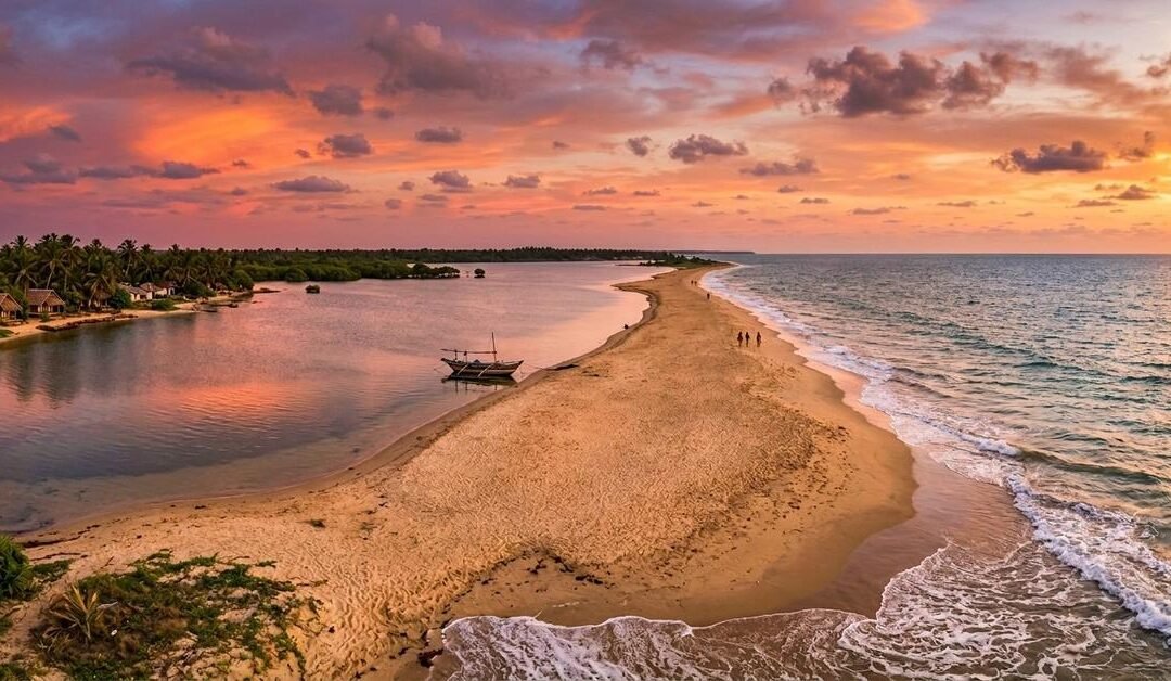
As I stepped onto the sand spit for the first time, the world seemed to pause. The sea sparkled on one side. The lagoon shimmered on the other. And in between stood this slender strip of golden sand, reaching out like a finger toward the deeper ocean.
It was love at first sight.
What to Do in Dutch Bay
Dutch Bay is not for people who crave loud, packed beach scenes. It’s for dreamers. Wanderers. People who want to feel the world breathe.
Here’s what filled my days:
1. Wander Along the Sand Spit
Dutch Bay’s sand spit is one of the most unique geographical features in Sri Lanka. It stretches impossibly far—narrow at points, widening at others, always bordered by blue.
Walk it. That’s my advice.
Early morning, when the light is soft and cool, the sand is patterned with bird tracks. Midday, the ocean is bright and bold. Sunset? Pure magic. The sky explodes into pinks and oranges, reflected on both sides by water.
At times, I walked barefoot with waves touching both ankles at once. It felt like walking on the spine of the world.
2. Dolphin Watching in Kalpitiya
Dutch Bay is one of the best launching points for dolphin watching on the island. Boats leave at dawn, cutting across the calm morning waters of the Indian Ocean.
I remember the exact moment when a pod of spinner dolphins leaped beside our boat—sleek, playful, dancing in arcs of sunlight. There were dozens, maybe hundreds, gliding effortlessly together.
If you’re lucky, you may also spot:
Bottlenose dolphins.
Risso’s dolphins.
Occasional whales cruising further offshore.
It’s humbling to witness.
3. Explore the Mangroves and Lagoon
Dutch Bay borders the enormous Puttalam Lagoon—one of Sri Lanka’s richest aquatic environments. Renting a kayak or joining a small lagoon ride lets you slip into a world of:
Mangrove tunnels.
Hidden sandbanks.
Fishermen balancing on narrow canoes.
Migratory birds perched like ornaments along the water’s edge.
The lagoon has its own rhythm—calmer, slower, reflective.
One evening, I drifted among the mangroves as the sun fell and the water turned to glass. It’s moments like that which stay etched in memory.
4. Kitesurfing (Even if You Don’t Try It!)
Even if you never strap into a kite, watching kitesurfers swooping across the lagoon is a spectacle. Dutch Bay and Kalpitiya are world-famous for strong, steady winds—perfect for the sport.
Giant colorful kites streak across the sky like tropical birds. Surfers glide over the surface with unbelievable finesse. The whole scene has an energy that makes you want to cheer.
If you’re adventurous, this is the place to take your first lesson.
5. Visit St. Anne’s Church Thalawila
A short drive south takes you to the historic St. Anne’s Church—one of the oldest and most beloved pilgrimage sites in Sri Lanka.
Its white façade stands out against the coconut fringes. Inside, it’s quiet, peaceful, and filled with the scent of old wood and candles. Even if you’re not religious, the atmosphere feels comforting.
6. Birdwatching Around the Lagoon
Dutch Bay is a paradise for bird lovers. Some of the species I spotted:
Grey herons.
Egrets.
Flamingos (seasonal, but worth dreaming about)
Brahminy kites.
Sandpipers.
Terns.
Pelicans.
The early mornings hum with wings.
7. Sunset Watching—The Ritual
Every evening, Dutch Bay becomes a theatre.
The wind calms slightly. Fishermen return with their boats. The sky begins to glow. The sand cools beneath your feet.
And then—the sun dips. First orange. Then pink. Then a deep purple that ripples across the sky like spilled ink.
Sunset here is not just something you watch. It’s something you feel.
Where to Stay
Most accommodations around Dutch Bay are boutique-style lodges, eco cabanas, or small hotels designed to blend with the natural environment. The vibe is relaxed, breezy, and tucked-away.
Expect stays with:
Cabanas nestled among palms
Open-air lounge areas
Hammocks slung between casuarina trees
Sea or lagoon views
Candlelit dinners under star-heavy skies
Some stays are close to the beach, while others sit along the lagoon—both options offer beautiful views and incredible silence at night.
I stayed in a small eco-lodge where evenings were spent listening to the wind and mornings began with strong tea and the call of seabirds.
What to Eat in and Around Dutch Bay
Seafood rules here.
Must-try dishes:
Fresh lagoon crab
Grilled sea fish caught at dawn
Prawn curry with coconut milk
Pol roti with spicy lunu miris
Tropical fruit platters with watermelon, pineapple, and papaya
One night, I ate dinner on the beach—bare feet in the sand, stars overhead, the sound of waves as the only music. If I could bottle that moment and keep it forever, I would.
What Makes Dutch Bay Special
I’ve visited many of Sri Lanka’s beaches—from Mirissa’s waves to Jaffna’s coves to Trincomalee’s soft sands. But Dutch Bay? Dutch Bay is different.
It’s untouched.
It’s quiet.
It’s windswept.
It’s wild.
It’s honest.
The beauty here is raw—like nature before it learned to perform for tourists. There are no crowds. No loud markets. No clusters of hotels competing for space. Just the sea, the lagoon, the mangroves, the wind, and the long sweep of sand that holds it all together.
At Dutch Bay, the world feels wider. The air feels lighter. And time feels slower.
My Last Morning in Dutch Bay
On my last morning, I woke before dawn and walked to the water’s edge. The world was still blue—half awake. The wind was soft for once.
Birds skimmed across the lagoon. Fishermen lit small lamps on their boats. The smell of the sea was sharp, clean, awakening.
I stood on the sand spit, shoes in hand, and watched the first golden line of sunlight stretch across the water.
And as the sky broke open into color, I realized something:
Dutch Bay is not just a destination.
It is a feeling—of being suspended between sea and sky, between noise and silence, between life’s rush and its hush.
It is a place where you remember how to breathe deeply.
Where you see beauty in simplicity.
Where your heart becomes a little lighter.
And long after you leave, you will carry it with you.
If you’re searching for a hidden corner of Sri Lanka where nature still speaks in its original voice, Dutch Bay is waiting—quiet, untouched, windswept, and impossibly beautiful.
by Travel Nomad | Mar 27, 2026 | Southeast Asia, Sri Lanka |
A first-person wander through Sri Lanka’s most atmospheric UNESCO World Heritage Site
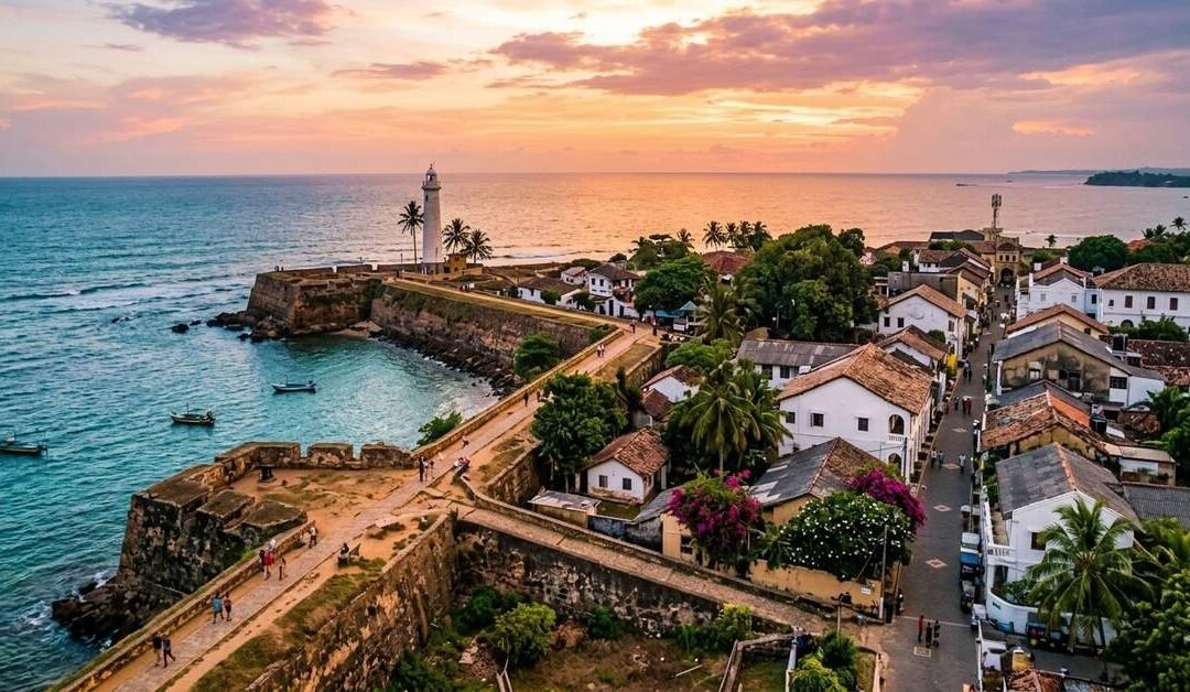
Galle Fort does something unusual for a historical monument: it functions. Not as a theme park version of itself, not as a carefully preserved ruin that you peer at through a fence, but as a living, inhabited, genuinely occupied city within a city. People are born here. Families have lived in the same houses for generations. The streets are narrow and the walls are thick and the Indian Ocean is visible from almost everywhere, and the whole thing operates with a confidence that suggests it has absolutely no interest in your opinion of it.
The Fort is a 36-hectare promontory on Sri Lanka’s south coast, first fortified by the Portuguese in the late 16th century, substantially rebuilt by the Dutch in the 17th and 18th centuries, and then absorbed into the British Empire without much fuss. Each colonial power left its marks in the architecture, the street plan, the place names. But the most interesting thing about Galle Fort isn’t its colonial history. It’s what the Sri Lankans did with that history once the colonisers went home: they moved in, made it entirely their own, and turned it into one of the most singular places in Asia.
I’ve visited a lot of UNESCO sites over the years, and many of them carry a faint air of obligation, as though you’re there because you’re supposed to be. Galle Fort never feels like that. It feels like a place worth being in for its own sake, on its own terms, without any particular agenda beyond walking and looking and letting the afternoon go where it wants to.
Getting There from Katunayake Airport
Galle is roughly 160 kilometres south of Bandaranaike International Airport, which sounds simple until you factor in Colombo traffic, which can add an unpredictable 45 minutes to an hour to your journey time depending on the hour of day. Total travel time from the airport to Galle Fort runs between two and a half and four hours. Build in the buffer. Sri Lanka will always find a way to use it.
The fastest and most comfortable option is the Southern Expressway by private car or taxi. The expressway bypasses Colombo entirely if you pick it up from the Katunayake junction, and the drive down to Galle takes under two hours in normal conditions. It’s a modern, well-maintained highway and the first stretch, before the road turns inland, gives you occasional flashes of the coast that serve as a reasonable preview of what’s coming. Hire a driver through your hotel or through PickMe or Uber, both of which operate in Sri Lanka. A knowledgeable driver is worth asking for by name if your accommodation can recommend one.
The train is the more atmospheric option and frankly one of the better train journeys in Asia. From Colombo Fort Station, the coastal line to Galle runs south along the shoreline with the ocean appearing and disappearing on your left as the train weaves between fishing villages, coconut groves, and seaside towns. The journey takes about two and a half hours on the intercity express. The views from the right-hand windows as you head south are consistently lovely, and the whole experience has a gentle, unhurried quality that puts you in exactly the right frame of mind for the Fort. You’ll need to get to Colombo Fort Station first, which is about 45 minutes from the airport by taxi.
Intercity buses from Colombo to Galle run frequently from the Bastian Mawatha terminal and take around two to three hours depending on which service you catch. The express buses are faster and air-conditioned. They’re not as scenic as the train but they’re perfectly comfortable and very straightforward to use. Again, you’ll need to make your own way to the Colombo terminal from the airport first.
Once in Galle town, the Fort is walkable from the main bus and train stations. It takes about ten minutes on foot from the Galle train station to the main gate of the Fort, which is a perfectly reasonable walk with luggage if you’re travelling light. Tuk-tuks are available outside both stations if you’re not.
What to See
The ramparts are where you start and where you’ll probably end up returning several times. The Fort’s walls run for nearly three kilometres around the promontory, and walking them gives you a continuously shifting perspective: the town below on one side, the ocean on the other, and the light changing constantly as the sun moves across the sky. The best times are early morning and the hour before sunset, when the stone takes on a warm, tawny quality and the sea turns colours that seem slightly implausible. But honestly, the ramparts are worth walking at any hour.
The Dutch Reformed Church, dating to 1755, is one of the Fort’s most striking buildings. The interior is largely unchanged from its original construction, with pew-end inscriptions and tombstones set into the floor that read like a compressed history of Dutch colonial life and death in Ceylon. The graves of merchants, military officers, and their families are laid out beneath your feet as you walk, and the dates and inscriptions are more affecting than any museum display.
The National Maritime Museum, housed in a Dutch warehouse on the harbour side of the Fort, focuses on Sri Lanka’s long relationship with the sea: ancient trade routes, traditional fishing craft, the natural history of the surrounding ocean. It’s not a vast collection but it’s thoughtfully presented and provides useful context for the Fort’s significance as a port.
The streets themselves are the real museum. Leyn Baan Street, Church Street, Pedlar Street: these narrow lanes are lined with Dutch colonial architecture in various states of elegant disrepair or careful restoration. Shuttered windows, tiled roofs, thick whitewashed walls. Bougainvillea spilling over courtyard gates. A cat asleep on a step outside a gem shop. A school in a building that’s been a school since the 18th century. The Fort rewards slow, undirected walking in a way that few places do.
The lighthouse at the southern tip of the Fort is the oldest in Sri Lanka, originally constructed by the British in 1848. It’s still operational, which seems right somehow. It remains exactly where it was built, doing exactly what it was built to do, while the world has changed entirely around it.
What to Do
Walk the ramparts at sunrise. Set your alarm, which will feel unreasonable at the time and entirely justified once you’re standing on the Fort walls at six in the morning with the ocean going gold below you and almost no one else around. The Fort at sunrise belongs to the people who live here: the fishermen heading out, the women sweeping their front steps, the monks walking in procession. It’s a completely different place from the busy, tourist-filled afternoon version, and it’s the better one.
Browse the shops and galleries, which are genuinely worth your time. The Fort has attracted an interesting mix of independent traders, local artisans, antique dealers, and small galleries over the years. You’ll find Sri Lankan handloom fabrics, local jewellery, antique maps and prints, handmade books, small-batch spices. It’s not a souvenir market in the conventional sense. The shops here have considered what they’re selling and the things they stock reflect that. Bring more cash than you think you need.
Eat and drink well. Galle Fort has, over the past decade, developed a food scene that would be impressive in a city ten times its size. Small restaurants and cafes occupy restored Dutch buildings throughout the Fort, offering everything from proper Sri Lankan rice and curry to wood-fired pizza to some genuinely excellent seafood. The rooftop at the Galle Fort Hotel, though the hotel itself is beyond the budget of most travellers, has a bar that’s worth visiting for a sundowner even if you’re not staying there. The view across the ramparts and the ocean from that terrace at dusk is exactly as good as it sounds.
Attend the Galle Literary Festival if your visit coincides with it. Held annually in January, it’s one of the better literary events in Asia and uses the Fort’s various indoor and outdoor spaces as its venues. Writers, readers, and the literary curious descend from around the world, and the combination of intelligent conversation about books and the Fort’s extraordinary setting produces an atmosphere that’s genuinely unlike any other festival I’ve attended.
Day trips from the Fort are easy and worthwhile. Unawatuna Beach, three kilometres east, is one of Sri Lanka’s most popular swimming beaches and is accessible by tuk-tuk in ten minutes. Hikkaduwa, further along the coast, has good snorkelling on its reef. Mirissa, about 40 kilometres east, is the departure point for whale watching trips between November and April. The hinterland behind Galle holds cinnamon plantations, rubber estates, and small Buddhist temples that receive very few visitors.
Where to Stay
Staying inside the Fort is unambiguously the right choice if you can manage it. The experience of waking up within the walls, of having the Fort’s streets available to you before and after the day visitors arrive, is qualitatively different from commuting in from outside each day. The Fort accommodates everyone from backpackers to honeymooners, and the range of options is wider than you might expect from such a contained area.
At the top end, several of the Fort’s historic Dutch houses have been converted into small boutique hotels of considerable elegance. These are typically eight to twelve rooms in restored colonial buildings with high ceilings, antique furniture, courtyard gardens, and the kind of attentive service that only small properties can provide. They’re not cheap by Sri Lankan standards, but the buildings themselves are extraordinary and the location is impossible to replicate.
Mid-range guesthouses in the Fort offer clean, comfortable rooms in historic buildings at considerably more accessible prices. Many are family-run, and the owners tend to be excellent sources of local knowledge: which restaurant opened recently, which lane is best for sunset photographs, when the cricket matches are played on the Fort grounds. Ask questions and pay attention to the answers.
Budget accommodation exists within the Fort but is limited. If you’re travelling on a tight budget, staying just outside the walls in Galle town proper is a practical alternative. The Fort is a short walk from anywhere in the town, and the savings can be significant. Unawatuna, three kilometres away, has a wide range of budget beach accommodation and is a popular base for day trips into the Fort.
Book ahead if you’re visiting between December and March, which is the dry season on the south coast and the period when the Fort is at its busiest. The January literary festival in particular fills accommodation weeks in advance. Outside peak season, the Fort is quieter and more itself, and many of the better guesthouses will have availability on shorter notice.
The Thing About Galle Fort
Most UNESCO World Heritage Sites are significant for what they were. Galle Fort is significant for what it continues to be. The history is real and the architecture is remarkable and the designation is entirely deserved. But the reason to come here isn’t principally to look at old buildings. It’s to spend time in a place where four centuries of layered history have produced something that feels, improbably, entirely alive.
The Muslim families who’ve traded here for generations. The Sinhalese craftsmen whose workshops occupy buildings the Dutch constructed. The Tamil residents whose grandparents moved here before independence. The small wave of internationally minded Sri Lankans who’ve opened restaurants and galleries in the past decade. All of them occupying the same 36 hectares, going about their lives within walls that were built by people who never imagined any of this.
That’s Galle Fort. Go slowly. Look at things carefully. Eat as many meals as you can justify. And walk the ramparts at least once in the dark, when the lighthouse beam sweeps out over the ocean and the Fort is quiet and the stars are clear and the whole place feels like a secret that somehow managed to stay one despite everyone knowing about it.
Some places are worth every bit of the journey. This is one of them.
by Travel Nomad | Mar 27, 2026 | Southeast Asia, Sri Lanka |
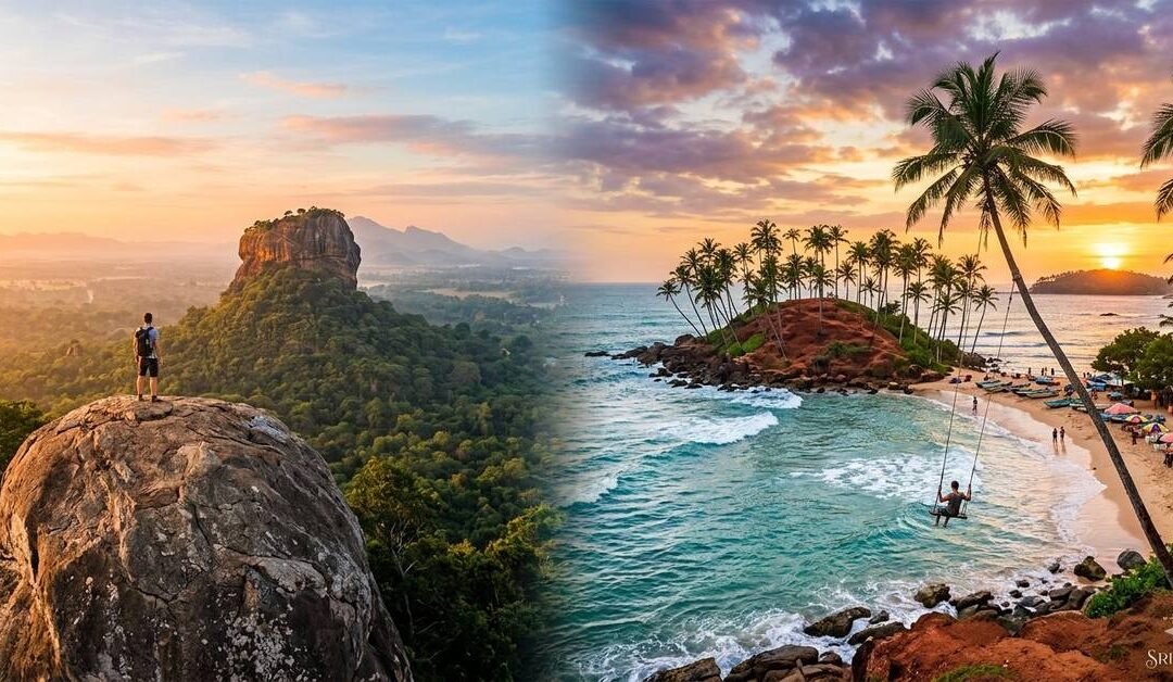
This isn’t about the Sri Lanka your parents visited. This is about the Sri Lanka that looks like a dream through a viewfinder, the one with the impossibly blue trains, the sunrise silhouettes, and the secret swings that make you feel like you’re flying over the Indian Ocean.
Over ten days, we’re hitting the spots that have turned this island into a global bucket-list favourite. But we aren’t just chasing the shot; we’re making sure you actually enjoy the moment before you press the shutter. This is a journey for the visual storyteller who wants a bit of grit with their glamour.
Day 1: The Raw Start in Negombo
Most people land at the airport and head straight for the hills. Don’t. Instead, head fifteen minutes down the road to Negombo. It’s a bit rough around the edges, but that’s exactly why it works.
Check into a beachside boutique somewhere with high ceilings and a bit of character. Spend your first afternoon just walking the shore. The sea here isn’t the turquoise blue of the south; it’s a moody, powerful grey green, dotted with the tanned sails of oruwa outrigger boats. It’s a very atmospheric start to the trip. Grab a ginger beer, sit on the sand, and let the jet lag settle.
Day 2: The Fish Market and the Northward Push
You’ll need to set an alarm for 5:00 AM. Trust me, it’s worth it. Head to the Lellama Fish Market. It’s a sensory explosion. You’ve got hundreds of fishermen bringing in the night’s catch mackerel, tuna, and massive sharks while the “dry fish” mats spread out for miles across the sand like a giant, textured quilt. The light at dawn here is incredible for photography; it’s all long shadows and silver scales.
By mid-morning, start the drive north. You’re heading for the Cultural Triangle. The road is lined with fruit stalls and coconut sellers. Stop for a king coconut the bright orange ones and watch the world go by. By late afternoon, you’ll arrive in the shadow of the great rocks.
Day 3: The View of the Lion
Everyone climbs Sigiriya. But if you want the shot of Sigiriya, you climb Pidurangala Rock.
Start your ascent at 5:00 AM. It’s a bit of a scramble at the top you’ll have to haul yourself over a few boulders but when you reach the summit, the view is staggering. You’re standing on a massive flat rock, watching the sun rise directly behind the Sigiriya Lion Rock. It’s one of those rare moments where the reality actually beats the photos.
Spend the afternoon resting. The heat in the dry zone is no joke. Head back out at dusk for a slow drive around the local lakes. The reflection of the trees in the water at sunset is the kind of quiet beauty that balances out the morning’s adrenaline.
Day 4: The Blue Train to Ella
Today is the “big one.” You’re heading to the mountains to catch the train. While the whole route is stunning, the stretch from Nanu Oya to Ella is the crown jewel.
This is the famous blue train you’ve seen everywhere. My advice? Don’t just sit in your seat. Head to the open doorways (carefully, of course) and feel the mountain air. You’ll pass through tea estates that look like they’ve been carpeted in emerald velvet and through tunnels that smell of old stone and woodsmoke. It’s a three-hour journey that feels like it’s over in twenty minutes.
Day 5: Bridges and Arches
Ella is a town built on views. Your first stop has to be the Nine Arches Bridge. It’s a massive colonial-era viaduct hidden in a jungle valley. To get the best perspective, walk along the tracks and then climb up into one of the tea-garden cafes overlooking the bridge.
If you time it right, you’ll see the blue train chugging across the arches. It’s a perfect bit of symmetry the stone architecture against the vibrant green jungle. Spend the rest of the morning at Little Adam’s Peak. It’s an easy climb, and the ridge line views are spectacular. In the evening, head into Ella town. It’s full of quirky, wood built cafes and bars that feel like a tropical version of a ski village.
Day 6: The Long Drop to the Coast
We’re leaving the mist behind and heading south. The drive from Ella down to the coast is a dramatic descent. You’ll pass Rawana Falls, a massive wall of water that crashes down right next to the road.
By afternoon, the air will turn salty. You’re heading for Mirissa. This is the capital of the “Instagrammable” south. Check into a guest house near the beach and head straight for the water. The vibe here is social, sun-drenched, and very laid-back.
Day 7: Palms and Promontories
This morning is about Coconut Tree Hill. It’s a small, red-earthed hill covered in a neat forest of palms, jutting out into the sea. You’ve definitely seen it on your feed. Go early, before the crowds arrive. The contrast of the red earth against the turquoise water is brilliant.
In the afternoon, head over to Dalawella Beach. This is where you’ll find the famous rope swing. Hanging from a bent palm tree, you can swing out over the lagoon as the sun sets. It’s a bit of fun, and it makes for an iconic silhouette shot. Afterwards, find a table on the beach and have a wood fired pizza while the tide comes in.
Day 8: The Stilt Fishermen and the Fort
As you start to move west towards Galle, keep an eye on the water for the Stilt Fishermen. While many now do it for the heritage (and the photos), the sight of men perched on single poles in the crashing surf is a testament to a very old way of life.
By afternoon, you’ll be in Galle Fort. This is a UNESCO World Heritage site and a photographer’s dream. The streets are a grid of colonial architecture, boutique shops, and vibrant bougainvillaea. Every doorway seems to be a different pastel shade. Walk the Ramparts at sunset the lighthouse against the darkening sky is the perfect way to wrap up the day.
Day 9: The Secret Garden of Bawa
On your way back toward Colombo, take a detour to Lunuganga. This was the country estate of the legendary architect Geoffrey Bawa. It’s a “designed” landscape that feels completely natural.
It’s a place of quiet, deliberate beauty. Bawa created “rooms” out of trees and vistas that draw your eye across the lake. It’s the opposite of the high-energy spots in Mirissa; it’s a place for slow, thoughtful photography. Have lunch on the veranda and just soak in the stillness.
Day 10: The Urban Wrap-up
Your final day is in Colombo. Don’t just head to the airport. Go to the Jami Ul-Alfar Mosque (the Red Mosque) in Pettah. Its candy-striped red and white brickwork is unlike anything else on the island.Then, finish your trip at Galle Face Green. Join the locals as they fly kites and eat street food at sunset. It’s the most authentic, un-curated moment you’ll have, and it’s a great way to say goodbye to an island that has given you a thousand different perspectives.
by Travel Nomad | Mar 25, 2026 | Southeast Asia, Sri Lanka |
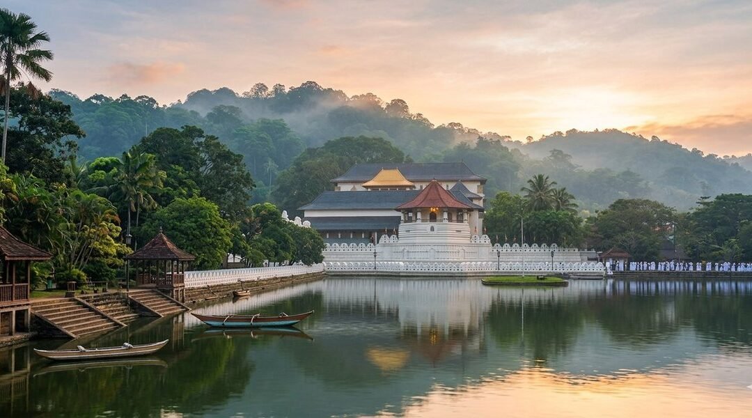
I didn’t expect to feel it. That’s the honest thing to say upfront. I’d seen temple complexes before: grand ones, ancient ones, ones that had been photographed so many times they’d almost become abstract. I walked into Sri Dalada Maligawa, the Temple of the Sacred Tooth Relic in Kandy, thinking it would be another beautiful ruin I’d tick off respectfully and move on from. Instead, I stood in a corridor thick with the scent of jasmine and incense, listening to drumbeats rolling up from somewhere deep inside the building, and felt the hairs on my arms stand up. Something about this place is different. It takes a moment to work out what.
It’s alive. That’s it. Most sacred sites you visit are preserved, curated, cordoned off, labelled. Sri Dalada Maligawa is in active, daily, devotional use by millions of Buddhists across Sri Lanka and beyond. The tooth relic of the Lord Buddha, housed here for centuries, isn’t a museum exhibit. It’s the most sacred object on the island, a symbol of sovereignty and spiritual power so significant that, historically, whoever possessed it was considered the rightful ruler of Sri Lanka. People come here to offer flowers, to pray, to weep, to give thanks. You’re not an observer. You’re a guest in someone’s most important place.
That distinction shapes everything about a visit here and it’s why, even if you’re not Buddhist, even if you’re not particularly spiritual at all, the Maligawa manages to get under your skin in a way that’s difficult to explain and easy to underestimate.
Getting There from Katunayake Airport
Kandy sits about 115 kilometres from Bandaranaike International Airport in Katunayake, which sounds manageable until you discover that the road climbs steadily into the hill country and the journey takes anywhere from three to four hours depending on traffic. Sri Lankan traffic, particularly around Colombo and on the main A1 highway, has a personality all of its own. Factor in extra time and treat the journey as part of the experience rather than an obstacle.
The most convenient option is a private car or taxi. Drivers can be arranged through your hotel or through reputable cab apps like PickMe or Uber, which both operate in Sri Lanka. A knowledgeable driver will point out things along the route — the Kelaniya Raja Maha Vihara temple, the turn-off towards the Pinnawala Elephant Orphanage, the moment the landscape shifts from coastal flatlands into lush, layered green hills. Ask for commentary. Most drivers are delighted to provide it.
The train is the other option, and it’s the better one if you’re not in a hurry. You’ll need to get yourself to Colombo Fort Station first, about 45 minutes from the airport by taxi, and from there, the train to Kandy departs regularly throughout the day. The journey takes roughly two and a half to three hours and the views as you climb through the hills are, without any exaggeration, some of the finest you’ll see from a train window anywhere in the world. Book an Observation Saloon seat if you can. The panoramic windows make a considerable difference.
Intercity express buses from Colombo to Kandy also run frequently and are faster than the train, if less scenic. The Colombo bus terminals can be chaotic if you don’t know them, so if you’re going the bus route, having your guesthouse or hotel point you in the right direction is worth doing.
What to See
The Maligawa complex sits on the southern shore of Kandy Lake, and the approach matters. Walk along the lake road if you have time. The white-walled temple rising above the water, with the hills of Kandy framing it behind, is the image you’ll carry home. The distinctive octagonal tower, the Pattirippuwa, juts into the sky above the main entrance and has become one of the most recognisable silhouettes in Sri Lanka.
Inside, you pass through a series of chambers that ascend towards the inner sanctum where the tooth relic is enshrined within a tower of golden caskets, one nested inside the other like a sacred Russian doll. The relic itself is rarely displayed. What you’ll see is the outermost casket, ornate and golden and very beautiful, behind a gilded fence. Pilgrims queue to make offerings at this point, and the atmosphere is intensely devotional. Move slowly. Don’t photograph people at prayer without permission. Let the moment be what it is.
The museum within the complex deserves more attention than it typically gets from visitors eager to reach the shrine room. It houses gifts presented to the temple by heads of state and dignitaries: elaborate ivory carvings, antique texts, ceremonial objects, alongside exhibits that trace the relic’s remarkable history, including its legendary journey from India to Sri Lanka in the 4th century, smuggled in the hair of a princess.
The Alut Maligawa, the new shrine room added in the 1980s, houses a large seated Buddha and is used for more contemporary religious gatherings. It’s architecturally different in character from the older sections of the complex, more open, more modern but no less sincere in its purpose.
Don’t miss the elephant stables at the rear of the complex. The temple has long kept elephants as part of its ceremonial tradition, and the largest and most revered, the Maligawa tusker, plays a central role in the Esala Perahera festival. Even outside festival season, there’s usually at least one elephant resident, and the sight of a ceremonially decorated elephant in this setting, within earshot of the drum music and the evening chanting, is something you don’t easily forget.
What to Do
Attend a puja. This is the single most important thing you can do at the Maligawa, and it’s freely open to all visitors. Pujas (devotional ceremonies) are held three times daily: at dawn around 6:30am, mid-morning around 9:30am, and in the evening around 6:30pm. The timing varies slightly so it’s worth confirming when you arrive, but the evening puja in particular is extraordinary. Drums and horns fill the air. The shrine room opens. Hundreds of people press forward with offerings of flowers and incense. The collective weight of devotion in that space is something you can physically feel.
Walk the perimeter of Kandy Lake after your visit. The lake was constructed in 1807 by the last Kandyan king, Sri Wickrama Rajasinha, and the path around it is one of the most pleasant urban walks in Sri Lanka. It takes about forty minutes at a gentle pace and gives you shifting views back towards the temple, as well as the chance to encounter the lake’s resident monitor lizards, which are implausibly large and entirely unbothered by human company.
If your visit coincides with July or August, you may be lucky enough to witness the Esala Perahera, one of the grandest religious processions in Asia and quite possibly the most spectacular event I’ve ever seen in fifteen years of travel. Over ten nights, the streets of Kandy fill with elaborately costumed dancers, fire-twirlers, Kandyan drummers, and a procession of decorated elephants carrying a replica of the sacred casket through the city. It’s overwhelming in the best possible sense. If there’s any chance of timing your trip around it, do.
The Kandy City Centre and the old market area are both worth an explore. Kandy’s bazaar, with its spice sellers, fabric shops, and gem traders, is lively and navigable without being too overwhelming. The city’s gem industry has deep roots. The hill country has produced sapphires, rubies, and cat’s eyes for centuries, and whether you’re buying or just looking, the gem shops around the lake are genuinely interesting to browse.
A short tuk-tuk ride from the centre, the Royal Botanical Gardens at Peradeniya are a magnificent half-day trip. Established in 1821, they house one of the finest collections of tropical plants in Asia, including an avenue of royal palms that feels almost absurdly grand, an orchid house that smells like a dream, and a 350-year-old Java fig tree whose root system has colonised a stretch of ground the size of a tennis court.
Where to Stay
Kandy has accommodation to suit most tastes and none of it is particularly hard to find. The question is really about what kind of experience you want, and how important that view of the lake is to you, because it’s rather worth having.
The most atmospheric option is one of the colonial-era properties on the hillsides surrounding the lake. These are typically older buildings with high ceilings, polished wooden floors, and gardens that cascade down towards the water. The views from the terraces back across Kandy, the temple roof catching the morning light, the mist burning off the hills, are the kind that make you sit with a second cup of tea longer than you’d planned.
For those wanting to be closer to the temple and the city’s daily life, guesthouses in the lanes around the bazaar area put you within easy walking distance of everything. These are usually family-run, with home-cooked meals and the kind of local knowledge you simply cannot find in any guidebook. Ask your host about the best time to visit the temple, which puja is least crowded, where to get a proper rice and curry that’s not aimed at tourists. The answers will serve you well.
Slightly further out, the villages in the hill country around Kandy (Hanthana, Ampitiya, Tennekumbura) offer homestays and small boutique properties with an even quieter, more rural character. From these, Kandy is easily accessible by tuk-tuk, and you get the bonus of waking up in a landscape that’s almost absurdly beautiful, with tea estates and spice gardens rolling out from your window in every direction.
If you’re visiting during Esala Perahera, book as far ahead as possible. Kandy’s accommodation fills up weeks in advance for the festival period, and prices reflect the demand. Shoulder season (late September through November, and February to April) offers a quieter, more relaxed Kandy experience, with the temple no less magnificent for having fewer people in it.
Before You Go
Remove your shoes before entering any part of the temple complex. There are racks provided, and the floors are largely smooth stone, so it’s not an ordeal. Dress modestly: covered shoulders and knees are required, and sarongs are available to borrow or purchase at the entrance if you’ve forgotten. Hats come off inside. Photography is permitted in most areas of the complex but not during the puja ceremonies themselves, so put the camera away and simply be present for those twenty minutes. It’ll be better for it.
The temple opens early and the morning light on the lake-facing facade is genuinely lovely. Early morning is also when the complex is quietest. The first puja draws devotees but fewer tourists, and there’s a contemplative quality to the place at that hour that the midday crowds inevitably dilute. If you can manage an early start, it’s worth it.
There’s a tendency, when travelling, to treat sacred sites as backdrops, to position yourself in front of them, take the photograph, and move on to the next thing. Sri Dalada Maligawa resists that treatment quite effectively. It draws you in slowly, through sound and scent and the visible sincerity of the people worshipping around you, until you find yourself standing still for longer than you’d intended, watching a woman press flowers to her forehead before the golden casket, wondering about faith and devotion and the things we build our lives around.
That’s the Maligawa doing what it’s apparently always done. Making you pause. Making you think. And sending you back out into the noise of Kandy’s streets feeling, somehow, a little bit lighter than you did when you arrived.
Go in the morning. Stay for the puja. Eat the curry after.