by Travel Nomad | Mar 27, 2026 | Southeast Asia, Sri Lanka |
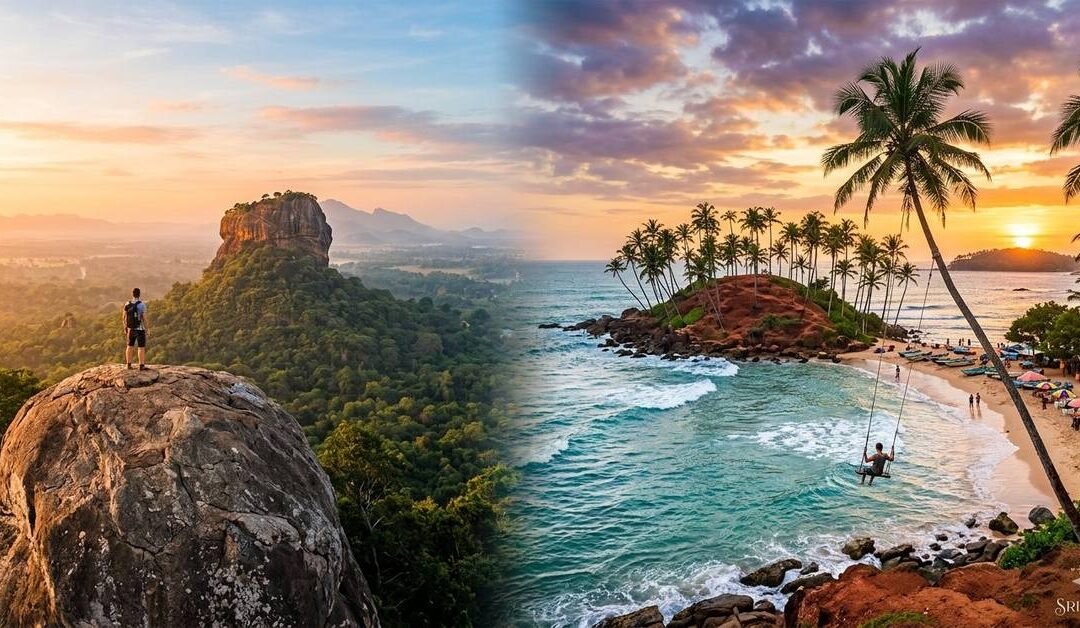
This isn’t about the Sri Lanka your parents visited. This is about the Sri Lanka that looks like a dream through a viewfinder, the one with the impossibly blue trains, the sunrise silhouettes, and the secret swings that make you feel like you’re flying over the Indian Ocean.
Over ten days, we’re hitting the spots that have turned this island into a global bucket-list favourite. But we aren’t just chasing the shot; we’re making sure you actually enjoy the moment before you press the shutter. This is a journey for the visual storyteller who wants a bit of grit with their glamour.
Day 1: The Raw Start in Negombo
Most people land at the airport and head straight for the hills. Don’t. Instead, head fifteen minutes down the road to Negombo. It’s a bit rough around the edges, but that’s exactly why it works.
Check into a beachside boutique somewhere with high ceilings and a bit of character. Spend your first afternoon just walking the shore. The sea here isn’t the turquoise blue of the south; it’s a moody, powerful grey green, dotted with the tanned sails of oruwa outrigger boats. It’s a very atmospheric start to the trip. Grab a ginger beer, sit on the sand, and let the jet lag settle.
Day 2: The Fish Market and the Northward Push
You’ll need to set an alarm for 5:00 AM. Trust me, it’s worth it. Head to the Lellama Fish Market. It’s a sensory explosion. You’ve got hundreds of fishermen bringing in the night’s catch mackerel, tuna, and massive sharks while the “dry fish” mats spread out for miles across the sand like a giant, textured quilt. The light at dawn here is incredible for photography; it’s all long shadows and silver scales.
By mid-morning, start the drive north. You’re heading for the Cultural Triangle. The road is lined with fruit stalls and coconut sellers. Stop for a king coconut the bright orange ones and watch the world go by. By late afternoon, you’ll arrive in the shadow of the great rocks.
Day 3: The View of the Lion
Everyone climbs Sigiriya. But if you want the shot of Sigiriya, you climb Pidurangala Rock.
Start your ascent at 5:00 AM. It’s a bit of a scramble at the top you’ll have to haul yourself over a few boulders but when you reach the summit, the view is staggering. You’re standing on a massive flat rock, watching the sun rise directly behind the Sigiriya Lion Rock. It’s one of those rare moments where the reality actually beats the photos.
Spend the afternoon resting. The heat in the dry zone is no joke. Head back out at dusk for a slow drive around the local lakes. The reflection of the trees in the water at sunset is the kind of quiet beauty that balances out the morning’s adrenaline.
Day 4: The Blue Train to Ella
Today is the “big one.” You’re heading to the mountains to catch the train. While the whole route is stunning, the stretch from Nanu Oya to Ella is the crown jewel.
This is the famous blue train you’ve seen everywhere. My advice? Don’t just sit in your seat. Head to the open doorways (carefully, of course) and feel the mountain air. You’ll pass through tea estates that look like they’ve been carpeted in emerald velvet and through tunnels that smell of old stone and woodsmoke. It’s a three-hour journey that feels like it’s over in twenty minutes.
Day 5: Bridges and Arches
Ella is a town built on views. Your first stop has to be the Nine Arches Bridge. It’s a massive colonial-era viaduct hidden in a jungle valley. To get the best perspective, walk along the tracks and then climb up into one of the tea-garden cafes overlooking the bridge.
If you time it right, you’ll see the blue train chugging across the arches. It’s a perfect bit of symmetry the stone architecture against the vibrant green jungle. Spend the rest of the morning at Little Adam’s Peak. It’s an easy climb, and the ridge line views are spectacular. In the evening, head into Ella town. It’s full of quirky, wood built cafes and bars that feel like a tropical version of a ski village.
Day 6: The Long Drop to the Coast
We’re leaving the mist behind and heading south. The drive from Ella down to the coast is a dramatic descent. You’ll pass Rawana Falls, a massive wall of water that crashes down right next to the road.
By afternoon, the air will turn salty. You’re heading for Mirissa. This is the capital of the “Instagrammable” south. Check into a guest house near the beach and head straight for the water. The vibe here is social, sun-drenched, and very laid-back.
Day 7: Palms and Promontories
This morning is about Coconut Tree Hill. It’s a small, red-earthed hill covered in a neat forest of palms, jutting out into the sea. You’ve definitely seen it on your feed. Go early, before the crowds arrive. The contrast of the red earth against the turquoise water is brilliant.
In the afternoon, head over to Dalawella Beach. This is where you’ll find the famous rope swing. Hanging from a bent palm tree, you can swing out over the lagoon as the sun sets. It’s a bit of fun, and it makes for an iconic silhouette shot. Afterwards, find a table on the beach and have a wood fired pizza while the tide comes in.
Day 8: The Stilt Fishermen and the Fort
As you start to move west towards Galle, keep an eye on the water for the Stilt Fishermen. While many now do it for the heritage (and the photos), the sight of men perched on single poles in the crashing surf is a testament to a very old way of life.
By afternoon, you’ll be in Galle Fort. This is a UNESCO World Heritage site and a photographer’s dream. The streets are a grid of colonial architecture, boutique shops, and vibrant bougainvillaea. Every doorway seems to be a different pastel shade. Walk the Ramparts at sunset the lighthouse against the darkening sky is the perfect way to wrap up the day.
Day 9: The Secret Garden of Bawa
On your way back toward Colombo, take a detour to Lunuganga. This was the country estate of the legendary architect Geoffrey Bawa. It’s a “designed” landscape that feels completely natural.
It’s a place of quiet, deliberate beauty. Bawa created “rooms” out of trees and vistas that draw your eye across the lake. It’s the opposite of the high-energy spots in Mirissa; it’s a place for slow, thoughtful photography. Have lunch on the veranda and just soak in the stillness.
Day 10: The Urban Wrap-up
Your final day is in Colombo. Don’t just head to the airport. Go to the Jami Ul-Alfar Mosque (the Red Mosque) in Pettah. Its candy-striped red and white brickwork is unlike anything else on the island.Then, finish your trip at Galle Face Green. Join the locals as they fly kites and eat street food at sunset. It’s the most authentic, un-curated moment you’ll have, and it’s a great way to say goodbye to an island that has given you a thousand different perspectives.
by Travel Nomad | Mar 25, 2026 | Southeast Asia, Sri Lanka |
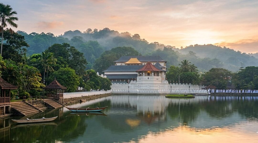
I didn’t expect to feel it. That’s the honest thing to say upfront. I’d seen temple complexes before: grand ones, ancient ones, ones that had been photographed so many times they’d almost become abstract. I walked into Sri Dalada Maligawa, the Temple of the Sacred Tooth Relic in Kandy, thinking it would be another beautiful ruin I’d tick off respectfully and move on from. Instead, I stood in a corridor thick with the scent of jasmine and incense, listening to drumbeats rolling up from somewhere deep inside the building, and felt the hairs on my arms stand up. Something about this place is different. It takes a moment to work out what.
It’s alive. That’s it. Most sacred sites you visit are preserved, curated, cordoned off, labelled. Sri Dalada Maligawa is in active, daily, devotional use by millions of Buddhists across Sri Lanka and beyond. The tooth relic of the Lord Buddha, housed here for centuries, isn’t a museum exhibit. It’s the most sacred object on the island, a symbol of sovereignty and spiritual power so significant that, historically, whoever possessed it was considered the rightful ruler of Sri Lanka. People come here to offer flowers, to pray, to weep, to give thanks. You’re not an observer. You’re a guest in someone’s most important place.
That distinction shapes everything about a visit here and it’s why, even if you’re not Buddhist, even if you’re not particularly spiritual at all, the Maligawa manages to get under your skin in a way that’s difficult to explain and easy to underestimate.
Getting There from Katunayake Airport
Kandy sits about 115 kilometres from Bandaranaike International Airport in Katunayake, which sounds manageable until you discover that the road climbs steadily into the hill country and the journey takes anywhere from three to four hours depending on traffic. Sri Lankan traffic, particularly around Colombo and on the main A1 highway, has a personality all of its own. Factor in extra time and treat the journey as part of the experience rather than an obstacle.
The most convenient option is a private car or taxi. Drivers can be arranged through your hotel or through reputable cab apps like PickMe or Uber, which both operate in Sri Lanka. A knowledgeable driver will point out things along the route — the Kelaniya Raja Maha Vihara temple, the turn-off towards the Pinnawala Elephant Orphanage, the moment the landscape shifts from coastal flatlands into lush, layered green hills. Ask for commentary. Most drivers are delighted to provide it.
The train is the other option, and it’s the better one if you’re not in a hurry. You’ll need to get yourself to Colombo Fort Station first, about 45 minutes from the airport by taxi, and from there, the train to Kandy departs regularly throughout the day. The journey takes roughly two and a half to three hours and the views as you climb through the hills are, without any exaggeration, some of the finest you’ll see from a train window anywhere in the world. Book an Observation Saloon seat if you can. The panoramic windows make a considerable difference.
Intercity express buses from Colombo to Kandy also run frequently and are faster than the train, if less scenic. The Colombo bus terminals can be chaotic if you don’t know them, so if you’re going the bus route, having your guesthouse or hotel point you in the right direction is worth doing.
What to See
The Maligawa complex sits on the southern shore of Kandy Lake, and the approach matters. Walk along the lake road if you have time. The white-walled temple rising above the water, with the hills of Kandy framing it behind, is the image you’ll carry home. The distinctive octagonal tower, the Pattirippuwa, juts into the sky above the main entrance and has become one of the most recognisable silhouettes in Sri Lanka.
Inside, you pass through a series of chambers that ascend towards the inner sanctum where the tooth relic is enshrined within a tower of golden caskets, one nested inside the other like a sacred Russian doll. The relic itself is rarely displayed. What you’ll see is the outermost casket, ornate and golden and very beautiful, behind a gilded fence. Pilgrims queue to make offerings at this point, and the atmosphere is intensely devotional. Move slowly. Don’t photograph people at prayer without permission. Let the moment be what it is.
The museum within the complex deserves more attention than it typically gets from visitors eager to reach the shrine room. It houses gifts presented to the temple by heads of state and dignitaries: elaborate ivory carvings, antique texts, ceremonial objects, alongside exhibits that trace the relic’s remarkable history, including its legendary journey from India to Sri Lanka in the 4th century, smuggled in the hair of a princess.
The Alut Maligawa, the new shrine room added in the 1980s, houses a large seated Buddha and is used for more contemporary religious gatherings. It’s architecturally different in character from the older sections of the complex, more open, more modern but no less sincere in its purpose.
Don’t miss the elephant stables at the rear of the complex. The temple has long kept elephants as part of its ceremonial tradition, and the largest and most revered, the Maligawa tusker, plays a central role in the Esala Perahera festival. Even outside festival season, there’s usually at least one elephant resident, and the sight of a ceremonially decorated elephant in this setting, within earshot of the drum music and the evening chanting, is something you don’t easily forget.
What to Do
Attend a puja. This is the single most important thing you can do at the Maligawa, and it’s freely open to all visitors. Pujas (devotional ceremonies) are held three times daily: at dawn around 6:30am, mid-morning around 9:30am, and in the evening around 6:30pm. The timing varies slightly so it’s worth confirming when you arrive, but the evening puja in particular is extraordinary. Drums and horns fill the air. The shrine room opens. Hundreds of people press forward with offerings of flowers and incense. The collective weight of devotion in that space is something you can physically feel.
Walk the perimeter of Kandy Lake after your visit. The lake was constructed in 1807 by the last Kandyan king, Sri Wickrama Rajasinha, and the path around it is one of the most pleasant urban walks in Sri Lanka. It takes about forty minutes at a gentle pace and gives you shifting views back towards the temple, as well as the chance to encounter the lake’s resident monitor lizards, which are implausibly large and entirely unbothered by human company.
If your visit coincides with July or August, you may be lucky enough to witness the Esala Perahera, one of the grandest religious processions in Asia and quite possibly the most spectacular event I’ve ever seen in fifteen years of travel. Over ten nights, the streets of Kandy fill with elaborately costumed dancers, fire-twirlers, Kandyan drummers, and a procession of decorated elephants carrying a replica of the sacred casket through the city. It’s overwhelming in the best possible sense. If there’s any chance of timing your trip around it, do.
The Kandy City Centre and the old market area are both worth an explore. Kandy’s bazaar, with its spice sellers, fabric shops, and gem traders, is lively and navigable without being too overwhelming. The city’s gem industry has deep roots. The hill country has produced sapphires, rubies, and cat’s eyes for centuries, and whether you’re buying or just looking, the gem shops around the lake are genuinely interesting to browse.
A short tuk-tuk ride from the centre, the Royal Botanical Gardens at Peradeniya are a magnificent half-day trip. Established in 1821, they house one of the finest collections of tropical plants in Asia, including an avenue of royal palms that feels almost absurdly grand, an orchid house that smells like a dream, and a 350-year-old Java fig tree whose root system has colonised a stretch of ground the size of a tennis court.
Where to Stay
Kandy has accommodation to suit most tastes and none of it is particularly hard to find. The question is really about what kind of experience you want, and how important that view of the lake is to you, because it’s rather worth having.
The most atmospheric option is one of the colonial-era properties on the hillsides surrounding the lake. These are typically older buildings with high ceilings, polished wooden floors, and gardens that cascade down towards the water. The views from the terraces back across Kandy, the temple roof catching the morning light, the mist burning off the hills, are the kind that make you sit with a second cup of tea longer than you’d planned.
For those wanting to be closer to the temple and the city’s daily life, guesthouses in the lanes around the bazaar area put you within easy walking distance of everything. These are usually family-run, with home-cooked meals and the kind of local knowledge you simply cannot find in any guidebook. Ask your host about the best time to visit the temple, which puja is least crowded, where to get a proper rice and curry that’s not aimed at tourists. The answers will serve you well.
Slightly further out, the villages in the hill country around Kandy (Hanthana, Ampitiya, Tennekumbura) offer homestays and small boutique properties with an even quieter, more rural character. From these, Kandy is easily accessible by tuk-tuk, and you get the bonus of waking up in a landscape that’s almost absurdly beautiful, with tea estates and spice gardens rolling out from your window in every direction.
If you’re visiting during Esala Perahera, book as far ahead as possible. Kandy’s accommodation fills up weeks in advance for the festival period, and prices reflect the demand. Shoulder season (late September through November, and February to April) offers a quieter, more relaxed Kandy experience, with the temple no less magnificent for having fewer people in it.
Before You Go
Remove your shoes before entering any part of the temple complex. There are racks provided, and the floors are largely smooth stone, so it’s not an ordeal. Dress modestly: covered shoulders and knees are required, and sarongs are available to borrow or purchase at the entrance if you’ve forgotten. Hats come off inside. Photography is permitted in most areas of the complex but not during the puja ceremonies themselves, so put the camera away and simply be present for those twenty minutes. It’ll be better for it.
The temple opens early and the morning light on the lake-facing facade is genuinely lovely. Early morning is also when the complex is quietest. The first puja draws devotees but fewer tourists, and there’s a contemplative quality to the place at that hour that the midday crowds inevitably dilute. If you can manage an early start, it’s worth it.
There’s a tendency, when travelling, to treat sacred sites as backdrops, to position yourself in front of them, take the photograph, and move on to the next thing. Sri Dalada Maligawa resists that treatment quite effectively. It draws you in slowly, through sound and scent and the visible sincerity of the people worshipping around you, until you find yourself standing still for longer than you’d intended, watching a woman press flowers to her forehead before the golden casket, wondering about faith and devotion and the things we build our lives around.
That’s the Maligawa doing what it’s apparently always done. Making you pause. Making you think. And sending you back out into the noise of Kandy’s streets feeling, somehow, a little bit lighter than you did when you arrived.
Go in the morning. Stay for the puja. Eat the curry after.
by Travel Nomad | Mar 19, 2026 | Southeast Asia, Sri Lanka |
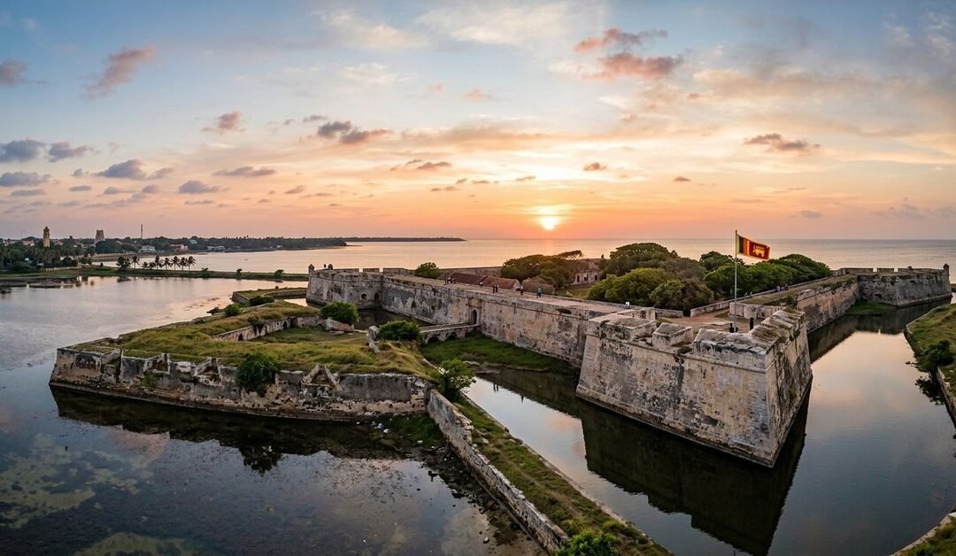
Getting to Jaffna requires commitment, which is probably why it still feels so real when you arrive. The fort was the first thing I walked to from my guesthouse, partly because it’s impossible to miss and partly because I wanted to understand the city before I started eating my way through it. I rounded a corner near the lagoon and there it was: a low, wide mass of pale stone sitting behind a moat, with grass growing thick over the sloping ramparts and a Sri Lankan Army flag flying from one of the bastions. It looked older than anything I’d expected. It looked, frankly, battered. And that, it turns out, is most of the point.
Jaffna Fort has been through four centuries of colonial occupation, multiple sieges, a prolonged civil war, and an ongoing restoration funded in part by the Dutch government, who built the thing in the first place and apparently still feel some responsibility for it. What remains is a structure that carries its history honestly, without the scrubbed-clean presentation of a museum exhibit. You can see where the LTTE blew out sections of the seaside rampart. You can see where the coral-and-limestone walls are being painstakingly rebuilt. And you can see, if you look carefully, the original Portuguese foundations beneath the Dutch expansion. It’s history told in layers of stone rather than text panels, and it’s all the more affecting for it.
How It All Started
The fort began as a Portuguese project. In 1618, a commander named Phillippe de Oliveira built a modest square structure here, just south of the town, on a strip of land where the lagoon narrows. He named it the Fortress of Our Lady of Miracles of Jafanapatao, a mouthful derived from a nearby church dedicated to the Virgin Mary. Four bastions, a moat, thick walls of coral and mortar. Functional rather than grand. For forty years, it served as the Portuguese stronghold in the north, repelling three local rebellions before the Dutch arrived in 1658 and did what the rebellions hadn’t managed.
Under Rijcklof van Goens, the Dutch took the fort, then completely remade it. Where the Portuguese had built a square, the Dutch built a pentagon. They added five triangular bastions at the corners, each named after a Dutch province: Zeeland, Holland, Gelderland, Utrecht, Friesland. The geometry wasn’t decorative. Those angled bastions were specifically designed to deflect cannon fire and eliminate the blind spots that straight walls created. It’s the kind of military engineering that only becomes obvious when you look at the fort from above, where the whole structure forms a near-perfect star shape against the lagoon. The Dutch also put up buildings inside: a church, a governor’s residence, a courthouse, warehouses, barracks. It was a small self-contained world.
The British arrived in 1795 and, in a manner that must have been somewhat anticlimactic after four decades of Dutch construction, took the fort without firing a single shot. They garrisoned it through independence in 1948, and afterwards the Sri Lankan Army moved in. Then came the civil war, the sieges, the LTTE occupation from 1990 to 1995, and the gradual, costly process of putting it back together again. The Dutch Reformed Church inside the fort walls was bombed. The Queen’s House and the King’s House, both colonial-era structures within the complex, were badly damaged. Some of the tunnels in the outer moat survived intact. Some didn’t.
Walking the Fort
You enter through the main gateway, which still carries the Dutch East India Company insignia above the arch. It’s the kind of detail that stops you mid-step. Step through and you’re on the parade ground, a broad open space that once served as the garrison’s operational centre and now feels quietly enormous. Depending on when you visit, there may be soldiers present; the fort is still a partial military installation, and access to certain areas is restricted. That said, the main circuit of the ramparts is open to visitors, and it’s where you want to spend most of your time.
Walk the walls. That’s the essential instruction for Jaffna Fort, and it’s not complicated advice. The ramparts give you a height advantage over the surrounding lagoon that feels slightly startling after the flatness of the peninsula, and on a clear afternoon the water stretches out in bands of grey and green towards the islands offshore. The views to the north over the town are equally good: the spindly colonial Clock Tower visible in one direction, the golden gopuram of Nallur Kandaswamy Kovil in another. Sunset from the seaside rampart is the kind of thing people photograph and then struggle to describe. The light comes in low over the lagoon and turns the damaged stone into something that looks almost deliberately beautiful.
Inside the fort, the ruins of the Dutch Reformed Church are worth seeking out. The broad limestone walls still stand to a reasonable height, roofless now, with weeds growing through the floor and the bell tower rising alone above the rubble. The Dutch government is funding its restoration, and scaffolding covers sections of the structure, which is a hopeful sign. Close to the seafront rampart, you’ll find the remains of a well believed to be from the Dutch period, and a small Hindu temple constructed at a later date. That combination, a Dutch well and a Tamil shrine, sitting quietly together inside the walls of a Portuguese fort, tells you something useful about Jaffna.
The five tunnels running beneath the outer moat have survived in reasonable condition and are worth a look if you can access them. They were originally fitted with doors to control entry and exit, and the scale of them suggests they were designed for moving troops and equipment quickly under fire rather than casual use. The whole moat system, the dry ditch, the ravelins, the angular outer walls, is a lesson in how seriously the Dutch took their defensive engineering. It all makes more sense once you’ve spent half an hour walking it.
Beyond the Fort Walls
Jaffna rewards a few days rather than a rushed afternoon. The Nallur Kandaswamy Kovil, a twenty-minute tuk-tuk ride from the fort, is one of the most significant Hindu temples in Sri Lanka and genuinely unlike anything in the south of the country. The towering golden-ochre gopuram is visible from some distance, and the courtyard inside is full of daily activity: pilgrims arriving with offerings, priests conducting rituals, devotees circling the inner sanctum. Men are required to remove their shirts before entering and everyone removes shoes at the gate. If you visit in July or August, the Nallur Festival runs for twenty-five days and turns the entire neighbourhood into something extraordinary.
The Jaffna Public Library is worth a visit for reasons beyond books. The original building, built in 1933 and one of the finest libraries in South Asia, was burned down in 1981 in an act of communal violence that became one of the defining symbols of the civil war. The rebuilt structure reopened in 2003 and holds over 97,000 volumes. Walking in, you feel the weight of what it represents. The library as an act of defiance and continuity.
For day trips, the Nainativu islands are accessible by bus from Jaffna station to Kurikadduwan Jetty, then a short ferry crossing. The island holds two important pilgrimage sites: the Nagadeepa Buddhist temple, one of the island’s most sacred, and the Hindu Nagapooshani Amman Kovil. Boats run frequently throughout the day. The Thirunelveli morning market is another local experience that repays an early start; the stalls are running by 5am and the whole place has the organised chaos of a space that’s been doing this for generations.
Where to Stay
Jetwing Jaffna is the most comfortable base in the city, a well-run hotel about 600 metres from the Public Library with a rooftop bar that has good coastal views and rooms decorated with Tamil art and textile patterns. It’s close enough to the fort and the Kovil to make a tuk-tuk unnecessary for most of your exploring, and the staff are genuinely helpful on the question of what to see and when.
For something with more local character, Jaffna Heritage Villa in the Nallur area puts you within a short walk of the Kandaswamy Kovil and the Royal Palace ruins, with a pool and bicycles available for hire. Useful if you’re planning to cover a lot of ground and want a bit of independence from tuk-tuk logistics.
Several well-regarded family guesthouses operate throughout the residential neighbourhoods of Jaffna and offer rooms that won’t be found on the major booking platforms. If you’re happy asking around on arrival or staying somewhere modest, this is a perfectly viable option, and the welcome you get in a family-run Jaffna home is often the most memorable part of a stay in the north.
Getting There from Katunayake Airport
Jaffna sits roughly 400 kilometres north of Bandaranaike International Airport, and getting there from Katunayake is the main logistical challenge of any northern Sri Lanka itinerary. Plan for it and it becomes manageable. Ignore it and you’ll find yourself improvising at Fort Station at 6am.
By Train via Colombo Fort
The train is the most recommended option and for good reason. Take the airport express bus, the 187 service, from outside the arrivals building to Colombo Fort Railway Station. That’s around 45 minutes. From Fort Station, the Yal Devi express is the fastest and most comfortable train to Jaffna, taking approximately six to seven hours north through the dry zone and up through the Vanni. It departs in the morning, so if you arrive at the airport in the evening, staying a night near Colombo and catching the early train the next day is a sensible plan. Book a reserved seat in the air-conditioned carriage. It’s genuinely worth it on a seven-hour journey, and the landscape changes dramatically as you move north.
By Private Taxi or Hired Car
A private car from Katunayake to Jaffna is a long drive, typically eight to nine hours depending on stops and traffic through Colombo. If you’re travelling as a group or with significant luggage, it can be the most practical option. Many drivers will suggest breaking the journey in Anuradhapura, which is genuinely worth considering: the ancient city is spectacular, roughly halfway, and adds a strong historical bookend to a trip that ends at a colonial fort. Most Colombo-based taxi services and travel agents can arrange this kind of transfer in advance.
By Bus
Overnight intercity coaches run from Colombo’s Pettah bus terminal to Jaffna, taking around eight hours and arriving in the early morning. They’re considerably cheaper than a private car and the air conditioning tends to be aggressive in a way that makes a jacket advisable. Getting to Pettah from the airport involves the express bus to Fort Station and a short walk or tuk-tuk across. Day buses also run, though they take longer. Buses work best if you’re travelling light and on a flexible schedule.
Practical Notes
The best time to visit Jaffna is between January and September, when the weather is dry and the roads are reliable. October and November bring heavy rain from the northeast monsoon, and some of the island day trips become impractical. The fort opens daily and is most comfortable in the early morning or late afternoon: midday in Jaffna is serious heat and the stone walls retain it. Wear shoes with grip if you’re planning to walk the ramparts, as some sections are uneven. Bring water. The fort doesn’t have a cafe.
Jaffna’s food scene is worth taking seriously. The cuisine here is distinct from the rest of Sri Lanka: heavily spiced, generous with dried fish and palmyra products, and genuinely excellent in the right hands. The local kool, a seafood broth unique to the north, is worth hunting out. Rio Ice Cream near the Nallur Kovil has been serving its signature sundaes for decades and is an institution that requires no further justification.
What Stays With You
Most people who visit Jaffna say that the fort wasn’t the part that moved them most. It’s usually something smaller: the library’s quietly determined shelves, a conversation with a tuk-tuk driver who remembers the war in personal terms, a puja ceremony at the Kovil at dusk, a ferry crossing to an island that holds two religions side by side without apparent difficulty.
But the fort sets the frame. It tells you, before you’ve done any of the rest, that this peninsula has been contested and argued over and grieved for and slowly, stubbornly rebuilt. The Portuguese named their fort after a miracle. The Dutch built theirs to last. The British took it without a fight. The civil war left its marks in blown-out walls and burned buildings. And now a trickle of visitors walk the ramparts at sunset, looking out over the lagoon towards India, while restoration workers patch the coral-and-limestone walls a few metres below.
Jaffna doesn’t soften its history for you. It just shows it to you and lets you decide what to make of it. That, more than the fort itself, is what makes the north worth every hour of the journey.
by Travel Nomad | Mar 18, 2026 | Southeast Asia, Sri Lanka |
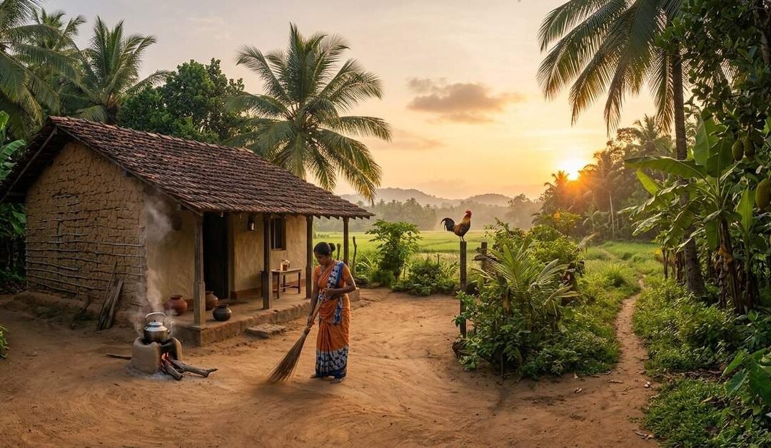
The first sound I heard wasn’t an alarm. It was a rooster arguing with the morning, followed closely by the clink of a kettle and the soft sweep of a broom across packed earth. In a Sri Lankan village, the day doesn’t begin—it slowly clears its throat.
I woke before the sun, the air cool enough to make you pull a sheet closer, the sky still undecided about its color. Somewhere nearby, a radio murmured yesterday’s news to no one in particular. This was not a place that rushed mornings. This was a place that allowed them.
Morning Tea: Where the Day Really Starts
Tea arrives early here, long before plans do.
A small glass, strong and sweet, finds its way into your hand as if it has always belonged there. Milk swirls into the dark liquid, steam fogs the rim, and suddenly the world feels manageable. People gather without calling it gathering—on verandas, under mango trees, beside open doors.
This is when the village wakes properly. Conversations begin with weather observations and drift toward crop gossip, relatives, and the whereabouts of a missing chicken. Dogs stretch theatrically. Motorbikes cough themselves awake. Someone laughs, loud and unguarded, the sound carrying easily in the open air.
You don’t check your phone. There’s nothing urgent enough to survive this tea.
The Mid-Morning Shift: Work Without Spectacle
By the time the sun climbs higher, the village has separated itself into motion.
Women move toward wells, gardens, and kitchens. Men head out with tools slung over shoulders or towels folded just so. Children appear briefly—washed, fed, already restless—before disappearing toward school.
I walk along a narrow path lined with fences made of sticks, wire, or nothing at all. Houses sit comfortably within their gardens, never pretending to be separate from them. Banana plants, chilies, curry leaves, and coconut palms blur the line between wild and intentional.
Work here doesn’t announce itself. It happens quietly: weeding, sweeping, repairing, feeding. No one looks busy for the sake of it. No one looks bored either.
Late Morning: Heat, Shade, and Stories
As the sun grows confident, movement slows. The village knows better than to fight midday.
People retreat into shade—under jackfruit trees, inside houses with windows flung wide, onto verandas where time seems to pause. This is when stories surface. Not formal ones, but fragments.
Someone tells me about a flood that came faster than expected. Someone else mentions a son working far away. There’s laughter, a sudden seriousness, then laughter again. Life here is spoken about plainly, without drama, without apology.
I notice how often people sit facing outward, watching the road, the fields, the sky. Nothing is missed, but nothing is stared at either.
Lunch Hours: The Quietest Part of the Day
Midday meals are hearty, unhurried, and followed by an understood lull.
After eating, the village seems to hold its breath. Shops close their shutters halfway. Roads empty. Even the dogs give up and collapse wherever shade allows.
I lie back on a wooden chair, listening to ceiling fans argue with the heat. Outside, leaves rustle lazily. A crow complains about something unseen. Time stretches, elastic and forgiving.
This is not wasted time. This is maintenance.
Afternoon: Life Creeps Back In
Slowly, the village exhales.
Children return first, uniforms rumpled, stories spilling out faster than they can be understood. Balls bounce. Gates open and close. Somewhere, a radio switches from talk to music.
I follow the sound of water and find people bathing at the edge of a stream, splashing without self-consciousness. Laundry appears on lines as if summoned. The air smells faintly of soap and damp earth.
Afternoons are informal here. No schedules, no announcements—just a shared sense that the day isn’t finished yet.
Evening: The Golden Hour Belongs to Everyone
As the sun begins its descent, the village becomes social.
People emerge again, refreshed. Conversations restart where they left off. Someone lights a small fire. Smoke curls upward, carrying the smell of coconut husks and cooking spices.
This is when walking feels essential. Roads glow amber. Fields turn soft and endless. Cows amble home with bells chiming gently, as if marking time.
I sit on a low wall and watch as the sky puts on its nightly performance—pink, orange, then purple, each color lingering just long enough to be appreciated.
No one rushes indoors. Night will come whether you’re ready or not.
Dusk: Between Day and Night
Dusk is my favorite part of the village day.
Lights flicker on one by one. Not harsh, not bright—just enough. The air cools slightly. Insects begin their evening chorus, testing the volume.
Dinner preparations start quietly. Pots clink. Flames flare. The rhythm of chopping settles into something almost musical.
People speak softer now. The day’s edge has dulled.
Nightfall: A Different Kind of Stillness
When darkness finally settles, it does so completely.
The sky fills with stars unconcerned with observation. The village contracts inward, homes glowing like small islands. Laughter leaks out through open windows. Somewhere, a television hums.
I step outside one last time. The night smells of earth and wood smoke. Crickets perform tirelessly. The road is empty, but not lonely.
There’s a comfort here that doesn’t come from entertainment or distraction. It comes from rhythm. From repetition. From knowing that tomorrow will look much like today—and that this is not a failure of imagination, but a success of living.
What the Village Teaches You
Spending a full day in a Sri Lankan village teaches you things no guidebook does.
That time can expand if you let it. That productivity isn’t always visible. That community doesn’t need constant affirmation—it exists in shared spaces, shared silences, shared routines.
I went to bed that night without feeling like I had done much. And yet, I felt full.
The rooster would argue with the morning again soon enough. The tea would arrive. The broom would sweep the earth clean.
And the village would continue, steady and unremarkable in the most remarkable way.
by Travel Nomad | Mar 17, 2026 | Southeast Asia, Sri Lanka |
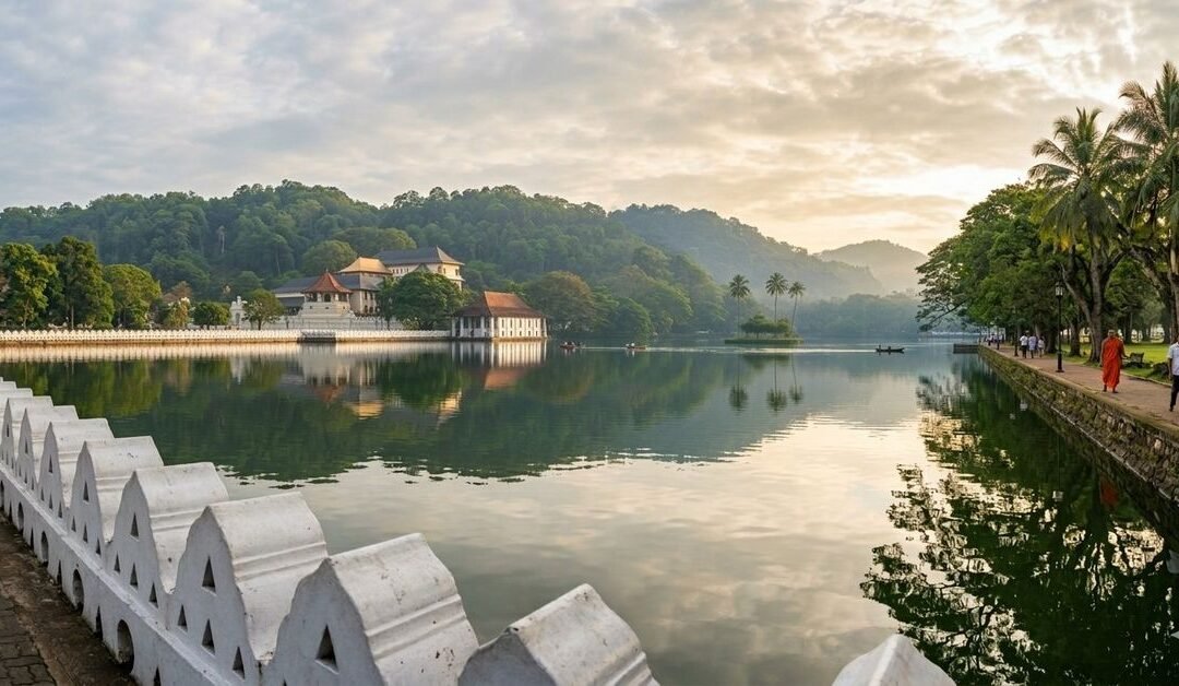
I found the lake by accident. I’d meant to go straight to the Temple of the Tooth, which is what everyone does, and instead I came around a bend in the road and the water was just there, flat and silver in the early light, the surrounding hills doubled perfectly in its surface. A cormorant sat on a low branch at the water’s edge, quite still, as if it had been posed for a photograph. I forgot about the temple entirely for a while.
Kandy Lake, known in Sinhala as Kiri Muhuda, which translates as the Sea of Milk, sits at the very centre of Sri Lanka’s cultural capital. Built in 1807 by King Sri Wickrama Rajasinghe, the last monarch of the ancient Kandyan kingdom, it was created by flooding a stretch of paddy fields called Tigolwela that lay in front of the Temple of the Tooth. The king’s architect, Deveda Moolacharya, dammed the land from both ends, leaving a small island in the middle that would become the subject of centuries of rumour and legend. The lake is entirely man-made and it doesn’t look it, which is probably the greatest compliment you can pay any feat of engineering.
A Kingdom’s Last Flourish
King Sri Wickrama Rajasinghe was not, by most historical accounts, a gentle ruler. His subjects reportedly resented the labour he demanded for his grand construction projects, including this lake. Yet there’s an irony in how the legacy turned out. His kingdom lasted fewer than a decade after the lake was completed. The British captured Kandy in 1815, deposed the king, and ended a line of Sinhalese monarchy that had resisted Portuguese, Dutch, and British colonisation for more than two centuries. What they couldn’t undo was the lake.
They repurposed it, of course. The small island at its centre, originally built as a summer retreat for the queen and the ladies of the court, was converted into an ammunition store and ringed with a fortress-style parapet. The elegant Queen’s Bathing Pavilion, a structure that sat partially submerged at the lake’s edge and served the king’s wives and concubines, was given an additional storey and turned into a library, then later a police post, which is what it remains today. It’s still worth pausing at, not despite its awkward history but because of it. The colonial additions sit a bit uneasily on the original Kandyan stonework, and somehow that tension makes the whole thing more interesting.
The most poignant detail belongs to the Walakulu Bamma, or Cloud Wall, the ornate parapet wall the king was building around the lake’s perimeter when the British arrived. It was never finished. The triangular openings in the wall were designed to hold oil lamps during festivals, and the sections that were completed still do their job beautifully during Esala Perahera each year. But the wall simply stops, mid-construction, where history interrupted it. That unfinished edge, running along the southern bank, says more about the end of a kingdom than any museum exhibit could.
What to See at and Around the Lake
The lake’s perimeter path runs for roughly 3.5 kilometres and it’s one of those rare urban walks that genuinely earns the word pleasant. The route takes you past ancient Nuga trees and tall palms, through patches of shade that feel meaningful in a Sri Lankan afternoon, and around to viewpoints where the Temple of the Tooth reflects off the water with the kind of symmetry that makes you question whether anything this composed can be real. The path is used by joggers and monks and schoolchildren and tourists in roughly equal measure. I like that about it.
The island at the centre, now called the Diyathilaka Mandapaya, is visible from most points on the walk and sits surrounded by palms behind its British-added wall. You can’t visit it directly, but it’s more atmospheric seen from a distance. The legend of the secret tunnel connecting it to the royal palace has never been confirmed, but nobody’s entirely disproved it either, which is how good legends survive. Birdwatchers will want to slow down along the northern bank: Indian cormorants, white egrets, pelicans, and the occasional painted stork have all been recorded here, and monitor lizards move through the shallows with the particular confidence of creatures that have been in Sri Lanka longer than anyone else.
The Temple of the Tooth (Sri Dalada Maligawa) is the lake’s most significant neighbour and really cannot be skipped. This UNESCO World Heritage Site houses a relic believed to be the sacred tooth of the Buddha, and its importance to Sri Lankan Buddhism is difficult to overstate. Dress modestly, remove shoes before entering, and try to arrive for one of the daily puja ceremonies, when the inner shrine is briefly opened to pilgrims. The sound of drums and the thick scent of incense in that moment is quite unlike anything else.
Above the lake, reached by a short uphill walk from the northern bank, is Udawattakele Forest Reserve. It’s a forest sanctuary that once served as the royal pleasure garden for Kandyan kings, and it’s still lush enough to feel genuinely wild. Trails wind through tall canopy cover, past streams and viewpoints and an old hermitage that dates to the colonial period. Macaques swing overhead, and on a quiet morning, when the mist is still sitting in the valleys below, the reserve has an atmosphere that the city can’t touch.
What to Do
Beyond the walk and the birdwatching, the lake itself offers traditional paddleboat rides from the small pier near the Queens Hotel. It’s a slow, unhurried way to see things from the water, and recommended at dusk when the hills around the city turn purple and the temple’s gilded roof catches the last of the light. Local children tend to gather near the water to feed the fish, which is a ritual apparently so universal across cultures that it requires no explanation.
If your visit coincides with the Esala Perahera festival, typically held in late July or August, you’ll witness something genuinely extraordinary. The procession passes near the lakeside, featuring dozens of magnificently dressed elephants, traditional Kandyan dancers, fire performers, and drummers in a procession that stretches for hours. The Cloud Wall’s lamp-holes are lit for the occasion, and the effect on the waterfront is exactly as theatrical as you’d expect from a festival that’s been running continuously for centuries.
Peradeniya Botanical Gardens, about five kilometres west of the lake, is worth a half-day excursion. One of Asia’s finest botanical collections, it was established on royal grounds and contains over 4,000 plant species, including a remarkable orchid house and a cannonball tree that blooms year-round. The avenue of royal palms leading into the garden is enough reason to go on its own.
Where to Stay
For sheer proximity and a very specific kind of colonial atmosphere, Queens Hotel is the obvious choice. It sits directly on the lakefront, its grand 19th-century facade looking out over the water and across to the temple. The building has hosted everyone from British governors to passing dignitaries, and the high-ceilinged rooms and wide verandas retain a faded grandeur that feels entirely appropriate for Kandy. Having breakfast with a lake view here is a pleasure that justifies the location.
Up on the Kandy hillside, the Amaya Hills resort offers panoramic views over the city and lake from a properly elevated position. The road up is vertiginous, the kind of Sri Lankan hillside driving that makes you trust the driver completely after approximately one minute, but the view from the top is worth every hairpin bend. It’s well-positioned if you’re planning a longer stay and want to use Kandy as a base for exploring the wider highlands.
For something more intimate, there are several well-regarded guesthouses in the residential streets above the lake. The Kandy House, an 18th-century Kandyan manor property a short drive from the centre, is often cited as one of the finest small hotels in Sri Lanka. It has the feel of a place where time moves differently. The rooms open onto a courtyard garden, the pool is carved stone, and the cooking is excellent. Worth it if you can get a room.
Getting There from Katunayake Airport
Kandy is about 100 kilometres from Bandaranaike International Airport at Katunayake, but road distance and journey time are two different things in Sri Lanka. The route climbs steadily into the hill country, and the roads, while scenic, don’t reward impatience. Allow between two and three hours depending on your chosen method and the time of day you’re travelling.
By Private Taxi or Pre-Arranged Transfer
The most comfortable and direct option. The official taxi counter in the arrivals hall at Katunayake is the safest way to book, and the journey takes roughly two to two and a half hours under normal conditions. Many drivers are happy to stop en route, and if you time your arrival right, a detour through Pinnawala to see the Elephant Orphanage makes for a fine way to ease yourself into the country. Pre-arranged private transfers offer the added benefit of a driver holding your name at arrivals, which is always reassuring after a long flight.
By Train via Colombo Fort
This is the most rewarding option if you have time and patience. From the airport, take the 187 express bus to Colombo Fort Railway Station, which takes about 45 minutes on the expressway. From Fort Station, trains to Kandy run roughly every two hours throughout the day, with the last departure around late afternoon. The journey takes two and a half to three hours and rises through remarkable countryside as it climbs into the hills, past terraced fields, rubber estates, and the edges of cloud forest. Book a reserved seat in advance if you can, especially at weekends, and book first class if you want a guaranteed window. The last train of the day from Colombo to Kandy departs before 6pm, so plan accordingly.
By Bus
Direct buses to Kandy depart from the Katunayake bus terminal, a short tuk-tuk ride from the arrivals building. The total journey including the transfer can take around five hours, depending on connections and traffic through Colombo. Intercity air-conditioned coaches from Colombo’s Bastian Mawatha Bus Terminal are a step up in comfort and run regularly throughout the day, taking around three to four hours. Buses are best tackled with modest luggage, a window seat, and a willingness to accept that the schedule is a suggestion rather than a promise.
A Few Practical Notes
The lake path is at its best in the early morning, before 8am if possible, when the air is cooler and the light is low and the cormorants are still out. Evenings are lovely too, particularly the stretch near Queens Hotel where locals gather to sit and talk. The midday heat is less forgiving, so plan heavy walking before 10am or after 4pm. The best months to visit are January through April, when the central highlands are dry and the skies tend to be clear. The Esala Perahera falls in July or August and draws enormous crowds, which is either a reason to go or a reason to avoid, depending on your temperament.
If you’re visiting the temple, dress accordingly: covered shoulders and legs are required. Many visitors carry a light scarf or sarong for exactly this reason. The temple also has a dress code around footwear, so shoes that slip off easily save a lot of fuss.
Why Kandy Lake Stays With You
Sri Lanka has more dramatic landscapes than Kandy. It has livelier cities and more remote corners and beaches that are genuinely jaw-dropping. But Kandy Lake has something that those places don’t, which is a kind of layered ordinariness. It’s a place where history and daily life share the same footpath. Where monks in saffron robes walk the same circuit as teenagers with earphones. Where a relic believed to determine the governance of an entire country sits in a gilded temple reflected in man-made water, and nobody finds that particularly strange.
The king who built this lake lost his kingdom three years later. The wall he designed was never finished. The island in the middle has been a royal retreat, an ammunition store, and a source of persistent rumour for two centuries. And yet the lake itself endures, unhurried and reflective, doing exactly what it was always meant to do: making the city look more beautiful than it otherwise would.
The cormorant was still there when I finally left, three hours after I’d arrived. Unmoved. Unimpressed. Utterly at home.
by Travel Nomad | Mar 16, 2026 | Sri Lanka |
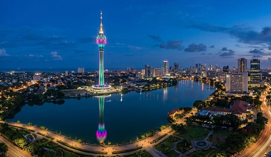
If you’ve ever thought Colombo was just about traffic jams and office buildings, think again. Towering over the city like a sentinel, the Colombo Lotus Tower is not just another skyscraper; it’s a spectacle that blends modern engineering with the grace of Sri Lankan design. At 350 meters, it’s the tallest structure in South Asia, and yes, it’s impossible to miss. Whether you’re a traveler, a photographer, or just someone who loves a bit of architectural drama, this tower has something for everyone.
Getting There from Katunayake Airport
Arriving from the Katunayake International Airport, which is roughly 40 kilometers from central Colombo, is easier than it seems. If you prefer comfort, a private taxi or a ride-hailing app will get you straight to the city in about 45 minutes to an hour, depending on traffic. For those feeling adventurous, the public bus system is an option, though it’s a slower ride and requires a bit of patience. Colombo’s train network also runs from Negombo near the airport to Fort Station in the heart of the city, offering a scenic glimpse of suburban life along the way.
Once in the city, the tower sits in the heart of Colombo 1, the central business district. From Fort Station, a short tuk-tuk ride or even a brisk walk takes you right to the tower’s base.
What to Do at the Lotus Tower
First off, you’ll want to take in the panoramic views. The observation deck is an absolute treat. On a clear day, you can see the Indian Ocean stretching into the horizon, the bustling streets of Colombo, and the lush greenery beyond. The experience is almost meditative, a rare moment of calm amidst a hectic city.
The tower is more than just a viewpoint. It houses a variety of attractions under one lotus-shaped roof. There’s a revolving restaurant that lets you dine while the city slowly spins beneath you. Imagine enjoying a traditional Sri Lankan curry while watching the sun set over the ocean—it’s a memory you won’t easily forget.
For those interested in culture, the Lotus Tower also features exhibition spaces that highlight Sri Lanka’s rich heritage. Temporary exhibits, art installations, and interactive displays often rotate through, giving visitors a fresh experience each time.
Capturing the Perfect Photo
Photographers, listen up. The tower’s unique lotus-inspired design is a marvel from every angle. Daytime shots against a bright blue sky are striking, but the real magic happens at night. The tower lights up in a dazzling display, reflecting in the nearby Beira Lake and creating a perfect mirror image. It’s one of those sights that make you want to pull out your camera, even if you swore you’d just enjoy the view.
If you’re feeling creative, wander around the base. The surrounding gardens and fountains make for excellent foregrounds, turning a simple photo into something cinematic.
Nearby Attractions
Since you’re already in central Colombo, there’s no shortage of things to do after visiting the tower. A short walk or tuk-tuk ride will take you to Galle Face Green, a wide-open space by the sea where locals fly kites, jog, and savour street food. For a touch of history, the Colombo National Museum isn’t too far, and it’s perfect for a lazy afternoon of exploring artefacts and colonial architecture.
Shopping enthusiasts can wander through the Dutch Hospital Shopping Precinct, where boutique stores, cafes, and eateries offer a pleasant mix of modern and traditional experiences. And if you’re in the mood for a sunset stroll, the Beira Lake area nearby provides a peaceful escape from the city buzz.
Where to Stay
Colombo has accommodation options to suit every type of traveller. If you want to be close to the Lotus Tower and other central attractions, consider staying in Colombo 1 or 2. Hotels range from luxury stays with rooftop pools and city views to charming boutique hotels that offer personalised service and a homely feel.
For those who prefer a quieter environment, the areas of Cinnamon Gardens or Kollupitiya offer a more residential feel while still being a short drive from the tower. Many hotels here offer easy access to restaurants, cafes, and shops, making it convenient to explore the city on foot or by tuk-tuk.
Food and Local Flavors
Colombo’s food scene is as diverse as the city itself. Near the Lotus Tower, you’ll find everything from local street food stalls to high-end restaurants. Don’t miss trying hoppers, string hoppers, and kottu roti. For dessert, coconut-based sweets are a must. And of course, Sri Lankan tea is everywhere—perfect for a mid-afternoon pick-me-up.
Practical Tips
The best time to visit the Lotus Tower is during clear weather to enjoy unobstructed views. Early morning or late afternoon visits can give you the advantage of cooler temperatures and softer light for photography. While there, take your time. It’s easy to get caught up in the height and the views, but the tower’s design, gardens, and surrounding areas deserve just as much attention.
Safety is straightforward: the tower is well-maintained and supervised. Shoes are fine to wear, though comfortable walking shoes are recommended if you plan to explore the base gardens and surrounding areas.
Wrapping Up
The Colombo Lotus Tower is more than just a building; it’s an experience. It captures the spirit of modern Sri Lanka while paying homage to its natural beauty and cultural depth. Whether you’re visiting for the views, the food, the photography, or simply to marvel at human ingenuity, the tower has a way of making you feel like you’re standing at the edge of something bigger than yourself.
So, next time you’re in Sri Lanka, make sure Colombo is more than just a stopover. Let the Lotus Tower be your first taste of what the city has to offer. Take a deep breath, look out over the sprawling city below, and let the journey begin.