by Travel Nomad | Apr 9, 2026 | Southeast Asia, Sri Lanka |
If you’ve already ticked off the tea estates and the southern beaches, or if you simply prefer your travel with a bit more grit and a lot less glitter, then the North of Sri Lanka is calling. For a long time, this region was off-limits, a place of mystery and hardship. Today, it’s one of the most rewarding parts of the island to explore, but it requires a different mindset.
The North doesn’t give itself up easily. It’s a landscape of palmyrah palms instead of coconut trees, of scorched earth instead of misty mountains, and of a culture that feels distinct—closer to South India in its flavours and rhythms, yet uniquely Sri Lankan in its resilience. This 9-day journey is for the traveller who wants to see the edges of the map.
Day 1: The First Capital Anuradhapura
Our journey begins in the Cultural Triangle, but we’re bypassing the crowded rocks for the sprawling ruins of Anuradhapura. This was the seat of Sinhalese royalty for over a thousand years.
The best way to see it is on a bicycle. The site is massive, and there’s something quite peaceful about pedalling between gargantuan white stupas like the Ruwanwelisaya that rise out of the jungle like stone mountains. Don’t feel like you have to see every single ruin. Instead, find a spot near the Jaya Sri Maha Bodhi, the oldest human-planted tree in the world. Watch the pilgrims in their white sarongs, listen to the rhythmic chanting, and just soak in the weight of history. It’s an architectural landscape built on faith and longevity.
Day 2: The Gateway to the North
- Travel Time: Anuradhapura to Jaffna (~3.5 to 4 hours)
Today, we cross “The Elephant Pass.” Historically, this narrow strip of land was the only gateway to the Jaffna Peninsula. The drive is a lesson in transition. The lush greens of the south slowly fade into a flat, arid landscape dominated by the iconic, tall silhouettes of palmyrah palms.
When you arrive in Jaffna, you’ll immediately notice the difference. The air is drier, the colours are brighter vibrant pinks, oranges, and blues on the houses and the sound of temple bells replaces the distant hum of the hills. Check into a local guest house, have your first real Jaffna crab curry (it’s spicy, messy, and brilliant), and just take a slow walk through the town centre to get your bearings.
Day 3: Temples and Turmeric
Jaffna is a city of temples, and the Nallur Kandaswamy Kovil is its golden heart.
You’ll need to visit in the morning or evening during the Pooja. Men are required to enter shirtless as a sign of respect, and the atmosphere inside is electric. The scent of heavy incense, the vibrant murals depicting Hindu mythology, and the sight of the gold-plated arches are staggering. It’s a masterpiece of Dravidian architecture.
In the afternoon, head to the Jaffna Fort. Originally built by the Portuguese and later expanded by the Dutch, it’s a massive, star-shaped fortification made of coral stone. It’s seen a lot of history much of it painful but as you walk the ramparts at sunset looking out over the lagoon, there’s a profound sense of peace. It’s a great spot to see the city from above and watch the local cricket matches being played in the dry moats below.
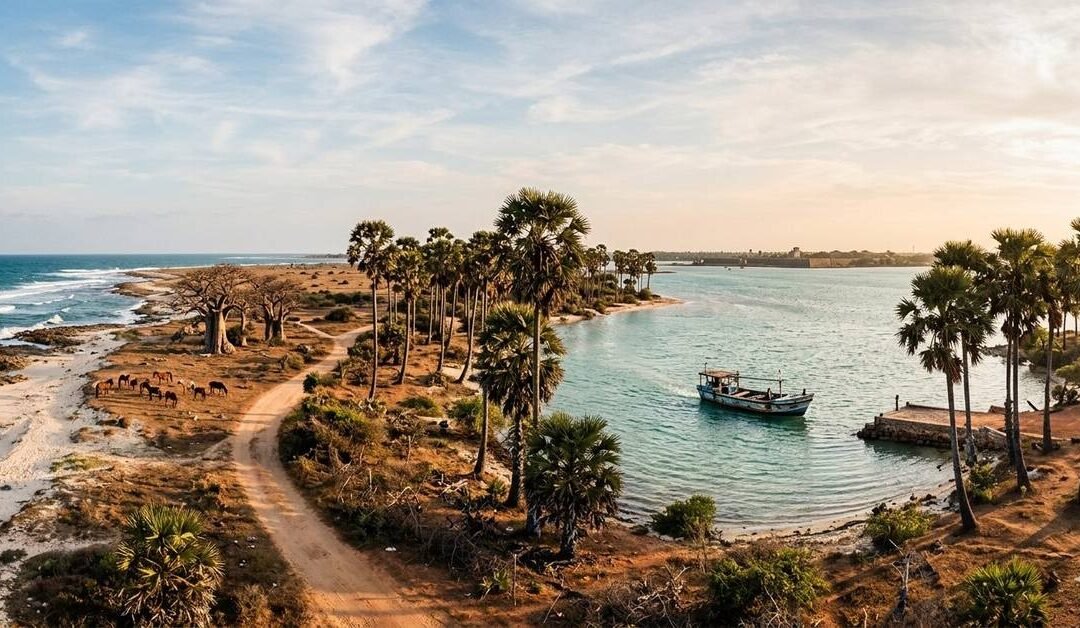
Day 4: The Island Life Delft Island
Today is an adventure. You’ll head to the Kurikadduwan jetty to catch a local ferry to Neduntheevu, or Delft Island. This is a place that feels like it’s been forgotten by the 21st century.
The island is made entirely of coral. The fences are built from chunks of coral stacked on top of each other, and the landscape is stark and beautiful. You’ll see the famous wild ponies, descendants of horses left behind by the Dutch centuries ago. Look for the “Growing Stone” a coral outcrop that locals swear gets taller every year and the hollowed-out Baobab tree. There are no fancy cafes here; just sun, salt, and a pace of life that makes “slow” look fast. It’s one of the most unique architectural and natural landscapes you’ll ever see.
Day 5: The Tip of the Island – Point Pedro
Head further north to Point Pedro, the northernmost point of Sri Lanka. It’s a quiet, wind-swept town with a long fishing history. Walk along the white sands of Manalkadu, where you’ll find a series of sand dunes and the ruins of an old church partially buried by the shifting sands.
The architecture here is simple and functional, designed to withstand the harsh northern sun and the salty spray. Spend the afternoon at the Keerimalai Sacred Water Spring. It’s a natural spring right next to the sea, where the fresh water is said to have healing properties. Swimming in the stone-walled pool while watching the waves of the Palk Strait crash just a few feet away is a highlight of any northern trip.
Day 6: The Giant of Mannar
- Travel Time: Jaffna to Mannar (~3 hours)
We’re moving west now to the Mannar Peninsula. This is a part of the country that feels even more remote than Jaffna. Mannar is famous for its Baobab trees, brought over by Arab traders over 700 years ago. These massive, prehistoric-looking trees give the landscape a surreal, African savannah vibe.
Check into a simple lodge. Mannar is a major stop for migratory birds, so even if you aren’t a “birder,” the sight of thousands of flamingos turning the lagoons pink is something you won’t forget. It’s a stark, minimalist kind of beauty that rewards the patient traveller.
Day 7: The Bridge to Nowhere – Talaimannar
Drive to the very end of the peninsula to Talaimannar. From here, India is just 30 kilometres away across Adam’s Bridge (Rama Sethu) a chain of limestone shoals that once connected the two countries.
You can walk out onto the pier and look across the water. It’s a place of incredible significance in the Ramayana, and standing there, you feel the weight of the myth and the geography. Visit the Talaimannar Lighthouse and the old railway pier, which used to be the hub for the “Boat Mail” train from Colombo to Chennai. It’s a haunting, evocative place that feels like the edge of the world.
Day 8: The Wild Frontier – Wilpattu
- Travel Time: Mannar to Wilpattu (~2.5 hours)
As we start to loop back south, we stop at Wilpattu National Park. This is the largest and oldest national park in Sri Lanka, and it is vastly different from the crowded trails of Yala.
Wilpattu is famous for its villus natural, rainwater filled lakes that dot the landscape. The architecture of the park is defined by these water bodies and the dense dry zone jungle. Because it’s less visited, the experience is much more intimate. You’ll track leopards and sloth bears through the thickets, and the sense of isolation is profound. Spend the night in a tented camp on the border of the park, listening to the night jars and the distant roar of a leopard.
Day 9: Reflection and the Journey Back
On your final day, take a slow drive back toward Colombo or the airport. The road from Wilpattu takes you through small villages and past ancient tanks (reservoirs) that have sustained life here for millennia.
The North isn’t a place you go for a “holiday” in the traditional sense. It’s a place you go for a perspective. You’ll leave with a deep respect for the people who have rebuilt their lives here, and a memory of a landscape that is as honest as it is beautiful. It’s the perfect end to a journey that has taken you off the beaten path and into the true soul of the island.
by Travel Nomad | Apr 8, 2026 | Southeast Asia, Sri Lanka |
A first-person journey into the wet, wild, and gloriously overlooked heart of Sri Lanka’s southern hills
There’s a particular kind of green that exists only in a proper rainforest. Not the cheerful green of a well-watered garden, not the lush green of the tea hills further north. This is something darker, denser, almost alive in the way it presses against you. It’s the green of a place that gets more rain than it knows what to do with, where moss colonises everything that stays still for more than a fortnight, and where the light arrives filtered and diffused, as though the forest has decided to take the edge off it before letting it through. That is the green of Rakwana.
Rakwana sits in the Sabaragamuwa Province, in the deep south of Sri Lanka’s central highlands, and it is one of those places that the travel industry hasn’t quite got around to yet. The more famous hill country towns, Nuwara Eliya, Ella, Haputale, have their own considerable charms, and they’re well-documented. Rakwana is different. It’s quieter, less polished, and surrounded by some of the most biodiverse forest in the entire country. The Sinharaja Forest Reserve, a UNESCO World Heritage Site and one of Asia’s last remaining lowland wet evergreen rainforests, begins practically on its doorstep.
I came here on the recommendation of a man I met on a train, which is exactly the kind of travel origin story that sounds made up but isn’t. He told me Rakwana was the real hill country, the one before the tourists arrived. Three days into my stay, soaked to the skin after a waterfall hike and eating rice and jackfruit curry on a guesthouse veranda while mist rolled in off the forest, I thought he might be right.
Getting There from Katunayake Airport
Rakwana is roughly 170 kilometres from Bandaranaike International Airport, but the journey takes longer than that distance suggests. The roads into the southern highlands are winding, hilly, and occasionally spectacular, and they reward patience rather than speed. Budget four to five hours from the airport depending on your route and whether Colombo traffic decides to be cooperative.
A private car hire is the most comfortable option and gives you the most flexibility on timing. The route most drivers take goes south from Colombo along the Southern Expressway before turning inland through Ratnapura and up into the hills. Ratnapura itself, the ‘City of Gems’, is worth a stop if you have time. It sits in the foothills of the wet zone and has been a centre of Sri Lanka’s gem mining industry for centuries. The streets around the market are full of small gem traders with pouches of sapphires and moonstones, and even a brief wander gives you a flavour of a trade that’s been happening here since antiquity.
By train, the most practical approach is to take the Colombo to Ratnapura line, which runs through the wet zone foothills and takes about three hours on the express service. From Ratnapura, local buses connect to Rakwana and the journey takes another hour and a half through increasingly dramatic hill scenery. The bus winds up through rubber and tea estates, past small villages and roadside shrines, and by the time you arrive in Rakwana you’ve already had a reasonable introduction to the landscape you’ve come to explore.
Direct buses from Colombo to Rakwana depart from the Bastian Mawatha terminal and take around four to five hours. They’re inexpensive, air-conditioned on the express services, and perfectly manageable if you travel with a sense of humour about schedule adherence. Sri Lankan intercity buses are rarely precisely on time, but they’re rarely very late either, and the journey itself is entertaining enough to compensate.
Once in Rakwana, tuk-tuks are available for local transport, though many of the forest trails and waterfall access points are best reached on foot or by motorbike. A few guesthouses can arrange motorbike hire or guided transport to the main sites. The roads deeper into the forest are narrow and sometimes unpaved, and having a local guide or at least a driver who knows them is genuinely useful rather than just a convenience.
What to See
Sinharaja Forest Reserve is the centrepiece and it’s worth spending the better part of a day inside it. The reserve covers over 11,000 hectares of primary rainforest, and within its boundaries lives an extraordinary concentration of endemic species. Over 60% of Sri Lanka’s endemic flowering plants are found here. So are 21 of the island’s 26 endemic bird species, which makes it one of the most important birding sites in Asia. The forest interior is genuinely dense, genuinely humid, and genuinely loud in a way that’s both overwhelming and wonderful.
The endemic bird species alone justify the journey for anyone with even a passing interest in wildlife. Blue magpies, Ceylon junglefowl, Sri Lanka grey hornbills, and green-billed coucals are among the birds you might encounter on a good morning in the forest. Sinharaja is famous for its mixed-species bird flocks, where dozens of different species move together through the canopy in a coordinated wave that lasts perhaps twenty minutes and leaves you standing in its wake feeling slightly overwhelmed by what you just saw.
The waterfalls around Rakwana are numerous and most are nowhere near as visited as they deserve to be. Bopath Ella, though technically closer to Ratnapura and therefore slightly better known, is shaped like the Sinhalese letter for ‘bo’ and plunges into a deep, cold pool that’s perfectly swimmable in the right season. Less well-known falls in the hills directly around Rakwana require more effort to reach but reward that effort with complete solitude and scenery that feels almost aggressively beautiful in the way only wet highland rainforest can manage.
The tea estates that cover the hillsides above and around the forest have a quality of light in the early morning that photographers will recognise immediately and everyone else will simply stare at. The rows of tea bushes, the women pluckers moving along them with baskets, the mist still caught in the valleys below, the occasional flash of a bright sari against the deep green: it’s a composition that repeats endlessly and never gets old.
The Rakwana market town itself is small and unpretentious, with a main street of shops, a produce market, a temple, a mosque, and the general unhurried atmosphere of a highland town that’s going about its business without much awareness of or interest in tourism. This is not a criticism. It’s one of the better things about it.
What to Do
Hire a local guide for Sinharaja. This is not an optional extra but a genuine practical necessity. The forest has no marked trails beyond the main entrance routes, and without someone who knows the paths, the bird call patterns, and the right places to wait and watch, you’ll see a fraction of what the forest has to offer. The Forest Department operates guided walks from the Kudawa entrance on the forest’s northern edge, and local naturalist guides based in Rakwana and the nearby village of Deniyaya know the southern entrances well. Book a guide who specialises in birding if that’s your priority, and ask specifically about the mixed-species flocks.
Walk the tea estate roads in the early morning. These aren’t formal trails, just the unpaved tracks that run between estates and along the ridge lines above Rakwana, but they’re open to walkers and the views they offer across the forested valleys to the hills beyond are as good as any in Sri Lanka. The mist is usually still in the valleys at seven in the morning and the light is extraordinary. Take water, take a jacket (it gets cold up here, genuinely cold, in a way that surprises people who associate Sri Lanka only with heat), and give yourself two to three hours.
Waterfall hunting is an activity that sounds slightly trivial until you’re standing at the lip of a 60-metre drop in the middle of primary rainforest with no one else within earshot. Ask your guesthouse about the lesser-known falls in the hills immediately around Rakwana. Several require a 45-minute to two-hour walk through rubber and forest to reach, and most have pools suitable for swimming. Go in the morning before the afternoon rains arrive, which they will, reliably and with conviction, every single day between October and April.
A visit to a working tea factory is straightforward to arrange and gives you useful context for the landscape you’re walking through. The factories around Rakwana process smaller, less touristy quantities than the big operations around Nuwara Eliya, and the tours tend to feel more personal and less rehearsed. You’ll taste the tea at the end, which sounds like a modest reward until you taste orthodox highland tea within an hour of it being produced, and then it makes sense.
Leech socks are worth purchasing before or during your visit if you plan to walk in the forest. The leeches of Sinharaja are small, numerous, determined, and completely harmless, but they have a habit of appearing in quantities that unsettle people who weren’t expecting them. Locals treat them as minor inconveniences. Tourists who arrive uninformed sometimes treat them as catastrophes. They are not catastrophes. Get the socks, tuck your trousers in, and concentrate on the birds.
Where to Stay
Accommodation in and around Rakwana is modest by the standards of the more developed hill country towns, and this is, again, largely a virtue rather than a drawback. What you lose in infrastructure you gain in quiet, in proximity to the forest, and in the kind of personal attention that only a small, family-run establishment can provide.
Several guesthouses operate in and around Rakwana town, offering simple rooms with attached bathrooms and meals on request. The food at the better ones is genuinely excellent. Wet zone hill country cooking has its own character: slightly different curry profiles from the dry north, heavier use of coconut, and a wider range of forest vegetables and greens that you won’t find in Colombo restaurants. Eat everything that’s put in front of you.
Closer to the Sinharaja forest entrances, particularly around the village of Deniyaya to the south and Kudawa to the north, there are small jungle lodges and eco-guesthouses that place you right on the forest edge. These are the best option for serious birders or anyone who wants to be in the forest at first light without a long drive to get there. Some have open verandas from which you can hear the forest at night, which is an experience worth having at least once. The soundscape of a Sri Lankan rainforest after dark is dense, layered, and quite unlike anything else.
For those who prefer a bit more comfort, there are a handful of small boutique-style properties in the wider Sabaragamuwa hills that offer better-appointed rooms, hot water (important at this altitude, where mornings can be genuinely chilly), and more polished food. These tend to have gardens that border the tea estates, and the views from their terraces are worth the slightly longer drive to the forest entrance.
Book ahead between December and April, which is the dry season for the south and the most popular period for forest visits. The forest is accessible year-round, but the trails are considerably muddier and the leeches considerably more abundant during the monsoon months. That said, some people specifically enjoy the forest in the rain, when the streams are full, the waterfalls are at maximum volume, and the forest smells, as one guide told me memorably, ‘like the whole island breathing out.
What Rakwana Actually Is
Sri Lanka is a small island that manages, improbably, to contain an enormous amount of different worlds within it. Beach resorts. Ancient cities. Tea country. Dry zone wilderness. Rakwana sits in the overlap between several of these worlds, in the wet, forested southern highlands where the ecology is extraordinary, the crowds are absent, and the pace of life is calibrated to the rhythm of rain and mist rather than tourist schedules.
It’s a place that asks something of you. It asks you to be comfortable with mud and mist and the occasional leech. It asks you to slow down enough to notice what’s happening in the canopy above you. It asks you to eat what’s available, walk when the light is good, and sit quietly when the birds are moving through. In return, it offers a version of Sri Lanka that most visitors never see, a country that is still, in these wet and forested hills, magnificently, stubbornly itself.
Bring waterproof boots. Pack a layer you can actually be warm in. Come without a fixed agenda and with a genuine willingness to be surprised.
The forest will do the rest.
by Travel Nomad | Apr 7, 2026 | Southeast Asia, Sri Lanka |
I didn’t arrive in Gal Oya with a checklist. I arrived with dust on my shoes, the smell of sun-warmed forest in the air, and the growing sense that I was drifting toward the edge of something quieter and older than the roads that led me here.
This part of Sri Lanka doesn’t announce itself. It doesn’t compete for attention. The backcountry around Gal Oya exists in a slower register, where jungle presses up against water, villages lean gently into the forest, and the reservoir holds more stories than reflections.
The First Impressions: Where Roads Thin Out
As I left the main highway behind, the road narrowed, then softened. Asphalt gave way to gravel, gravel to earth. The landscape thickened. Trees grew closer together. Villages appeared briefly—shops with sun-faded signs, dogs asleep in impossible positions, bicycles propped against walls—then vanished again into green.
Gal Oya’s backcountry is not a destination you rush toward. It reveals itself gradually, like a conversation that only deepens if you stay long enough to listen.
The Reservoir: A Body of Water With a Memory
The Gal Oya Reservoir arrived quietly, without ceremony. One moment I was driving through forest; the next, the land opened into water that seemed too wide, too calm, too deliberate to be accidental.
This reservoir is vast, but it never feels overwhelming. Dozens of forested islands rise from its surface, their edges softened by distance and mist. In the early morning, the water mirrors the sky so perfectly that it’s difficult to tell where one ends and the other begins.
I stood at the edge for a long time, watching ripples drift outward, thinking about how many villages, fields, and footpaths now rest beneath this still surface. The reservoir doesn’t erase what was here. It holds it.
What to Do: Moving at the Speed of the Land
The best way to experience Gal Oya’s backcountry is to slow down until your pace matches the place.
I spent mornings walking village paths that curved without reason, following sounds rather than directions. A woodpecker’s rhythm led me deeper into the forest. Children waved from doorways. A farmer pointed wordlessly toward a trail when I looked unsure.
Boat journeys across the reservoir reveal a different perspective. Forested islands drift past slowly, their trees leaning toward the water as if curious. Wildlife appears without warning—birds lifting suddenly from branches, crocodiles slipping soundlessly below the surface, deer pausing at the shoreline to drink.
Hiking through the surrounding jungle brings you face to face with the raw textures of the region. Tree roots twist across paths like frozen waves. The air smells of damp earth and leaves. Occasionally, the forest opens just enough to offer a glimpse of the reservoir below, shining through the canopy.
What to See: Wildlife Without the Spectacle
Gal Oya is known for wildlife, but the backcountry shows it to you differently.
Here, animals are not performances. They are presences.
Elephants move between forest and water along ancient routes, sometimes appearing at the reservoir’s edge in the late afternoon. Birds dominate the soundscape—calls layered upon calls, each species announcing itself with confidence. I spotted kingfishers skimming the surface, eagles circling high above, and peacocks strutting unapologetically through village clearings.
What struck me most was how seamlessly human life fits into this ecosystem. Villages exist not in opposition to the jungle, but in negotiation with it.
Life in the Backcountry Villages
Spending time in the villages around Gal Oya is an exercise in observation.
Days begin early. Smoke rises from cooking fires. Cattle are guided toward grazing land. People greet each other with easy familiarity, conversations unfolding slowly and often ending in laughter.
I sat on verandas, drank tea, and listened. Stories here are not delivered quickly. They circle, pause, double back. Topics drift from crops to rainfall to memories of before the reservoir, when the land looked different but life followed the same rhythms.
Evenings belong to the outdoors. Children play under fading light. Elders gather near doorways. The forest hums closer after sunset, reclaiming the edges of the village.
Where to Stay: Close to the Forest
Accommodation in Gal Oya’s backcountry is about proximity rather than luxury.
I stayed in places that felt intentionally quiet—lodges tucked into forest clearings, simple guesthouses run by families who know every bend in the nearby paths. Mornings arrived with birdsong instead of alarms, and nights settled in with the sound of insects and distant water.
Staying close to the reservoir or on the forest fringe allows the landscape to shape your day naturally. There’s no separation between where you sleep and where the experience begins.
The Reservoir at Different Hours
Gal Oya changes dramatically with the light.
Early mornings are hushed and misty. The reservoir feels like a held breath. Boats glide silently. Wildlife emerges cautiously.
Midday brings clarity and heat. The water turns blue and reflective. Forest edges sharpen.
But it’s evening that lingers longest in memory. As the sun lowers, the reservoir glows amber. Islands darken into silhouettes. Elephants sometimes appear at the waterline, their reflections stretching and breaking with each step.
Night transforms everything again. Stars reflect faintly on the water. Sounds carry farther. The forest feels closer, more intimate.
How to Get There from Katunayake Airport
Reaching Gal Oya’s backcountry from Katunayake Airport is a journey through changing landscapes.
By road, the drive takes you eastward across the island, passing through towns, farmland, and forest. Hiring a car with a driver allows for flexibility, letting you stop when something catches your attention.
Public transport offers a slower, more immersive route. Trains or buses can take you toward towns like Ampara or Inginiyagala, followed by local buses or tuk-tuks that wind into the backcountry. These final stretches are often the most memorable, revealing daily life in motion.
For those short on time, a domestic flight to a nearby regional airstrip can shorten the journey, with road transport completing the final leg.
No matter how you arrive, the last few kilometers feel like a transition—from movement to stillness.
What the Backcountry Teaches You
Gal Oya’s backcountry doesn’t overwhelm you with sights. It recalibrates you.
Here, silence is not empty. Stillness is not inactivity. The jungle and reservoir exist in a careful balance, shaped by time, water, and human adaptation.
I found myself listening more, speaking less. Watching patterns—of birds, of villagers, of light—and realizing how rarely modern travel allows for this kind of attention.
Leaving Gal Oya
When I eventually left, the road widened again. Signals returned. Noise crept back in.
But something had shifted.
Gal Oya’s backcountry stayed with me—not as a list of experiences, but as a feeling. A reminder that some places don’t need to be conquered, consumed, or even fully understood.
They only ask that you arrive slowly, stay quietly, and leave respectfully.
Where the jungle meets the reservoir, life flows at its own pace. And if you let it, it will quietly change yours.
by Travel Nomad | Apr 6, 2026 | Southeast Asia, Sri Lanka |
I didn’t mean to end up in the middle of the eastern wilderness, dust on my shoes and silence ringing in my ears — but Sri Lanka has a habit of pulling you off the main road and into stories far older than maps.
Seruwila Mangala Raja Maha Viharaya isn’t the kind of place you casually stumble upon. It doesn’t shout for attention, doesn’t compete with beach towns or hill-country lookouts, and doesn’t appear in glossy travel montages. Instead, it waits — surrounded by scrubland, forest, and the slow rhythm of rural life — quietly guarding one of the most sacred relics in the country.
This is not just a temple visit. It’s a pilgrimage through time.
First Impressions: A Temple That Emerges From the Wild
The road to Seruwila narrows as you approach. Villages thin out, trees press closer, and suddenly the modern world feels very far away. Then, rising calmly above the greenery, the white stupa appears — clean, circular, timeless. No dramatic entrance. No chaos. Just a sense that you’ve arrived somewhere that has been waiting for you longer than you’ve been alive.
Seruwila Mangala Raja Maha Viharaya is believed to enshrine the Lalata Dhatu, the sacred frontal bone relic of the Buddha. That alone makes it one of the most important Buddhist sites in Sri Lanka — yet it remains surprisingly uncrowded, especially compared to the southern and central pilgrimage circuits.
The atmosphere here is different. Quieter. Slower. More introspective.
A Little History (Without the Lecture)
According to ancient chronicles, this temple dates back over two thousand years, established during the reign of King Kavantissa. The area once sat along old trade routes that connected the east coast to inland kingdoms — a reminder that today’s wilderness was once very much part of a thriving world.
Centuries passed. Kingdoms fell. Forests reclaimed the land. The temple faded into obscurity, protected by isolation rather than walls.
Its rediscovery and restoration in the modern era feel less like a revival and more like a gentle reawakening.
What to See When You’re There
The Sacred Stupa
The heart of the temple is the stupa itself — serene, brilliant white, and perfectly balanced against the blue eastern sky. Walking clockwise around it, barefoot on warm stone, is a meditative experience even if you’re not on a spiritual quest.
There’s no rush here. No guides herding groups along. Just space to walk, pause, and breathe.
Shrine Rooms and Murals
Nearby shrine rooms house Buddha statues and wall paintings that reflect eastern Sri Lankan artistic styles — subtle, earthy, and deeply expressive. They don’t overwhelm you; they invite you in.
The Surrounding Grounds
Don’t miss walking the perimeter paths. The temple complex opens out into views of forested land and open sky, and it’s not uncommon to hear birds, distant temple bells, or simply the wind moving through trees.
This is one of those rare places where silence feels intentional.
What to Do Beyond Praying
Even if you’re not visiting purely for religious reasons, there’s plenty to engage with:
- Mindful walking around the stupa and grounds.
- Photography, especially early morning or late afternoon when the light softens everything.
- Quiet reflection or journaling — this place practically demands it.
- Observing daily temple life, from monks moving between buildings to villagers stopping by on their way home.
There’s no checklist here. The experience unfolds at its own pace.
Getting There From Katunayake Airport
Seruwila is in Sri Lanka’s Eastern Province, near Trincomalee, and reaching it is part of the adventure.
By Car or Taxi
From Bandaranaike International Airport (Katunayake), the journey takes you through the heart of the island.
- Route typically passes through Dambulla or Habarana before heading east toward Trincomalee.
- Roads are mostly good, with changing scenery from city to jungle to open plains.
- Ideal if you want flexibility and scenic stops along the way.
By Train + Road
A more relaxed (and very Sri Lankan) option:
- Travel from Negombo or Colombo to Trincomalee by train.
- From Trincomalee town, continue to Seruwila by tuk-tuk or private vehicle.
The train ride east is especially beautiful, cutting through forests and rural villages.
By Bus
Long-distance buses run toward Trincomalee from Colombo and surrounding hubs.
- Expect a slower journey.
- A great way to observe everyday life unfolding outside your window.
- From Trincomalee, local transport takes you the rest of the way.
No matter how you arrive, the final stretch feels like stepping out of the modern world.
Where to Stay
Seruwila itself is quiet and rural, so most travelers base themselves nearby.
Trincomalee
The best option for comfort and variety:
- Beachside guesthouses and small hotels.
- Easy access to Nilaveli and Uppuveli beaches.
- Good food options and transport connections.
You can visit the temple as a peaceful day trip from town.
Habarana or Dambulla (If You’re Looping the Island)
If Seruwila is part of a larger cultural circuit, staying inland works well:
- Convenient for combining with ancient cities.
- Early morning departures to the east are especially atmospheric.
When to Visit
Mornings are magical here. The air is cooler, the light is soft, and the temple feels almost suspended in time. Late afternoons are equally beautiful, with golden light settling over the stupa and long shadows stretching across the grounds.
Dress modestly, move quietly, and let the place guide your behavior — it naturally does.
Why Seruwila Stays With You
Some destinations impress you. Others entertain you. Seruwila does neither — and that’s exactly its power.
It grounds you.
Long after I left, what stayed with me wasn’t a photo or a fact, but a feeling: that I had briefly stepped into a rhythm older than noise, older than urgency. A place that doesn’t ask for attention, but rewards presence.
If you’re traveling through Sri Lanka and craving something deeper than beaches or ruins — something quieter, truer — make the journey east.
Seruwila Mangala Raja Maha Viharaya will be there, waiting, just as it always has.
Sometimes, the most sacred places aren’t hidden because they’re lost — they’re hidden because you have to slow down enough to find them.
by Travel Nomad | Apr 5, 2026 | Southeast Asia, Sri Lanka |
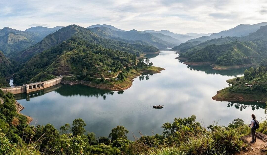
I didn’t come here looking for ruins. I came looking for water.
From photos alone, Rantembe and Randenigala appear calm, almost meditative—two vast reservoirs folded neatly into Sri Lanka’s hill country, reflecting clouds like they’ve got nothing to hide. It’s only when you stand at their edges, watching the surface hold its breath, that you realize these waters are not just scenic. They are full. Not only of rain and river, but of memory.
These reservoirs didn’t simply reshape landscapes. They erased villages.
Following the Mahaweli Into the Hills
The journey inland feels like slipping behind the scenes of Sri Lanka.
Leaving the western plains behind, the road climbs steadily toward Kandy, then continues eastward toward Mahiyanganaya. The air changes. The crowds thin. The land begins to speak more quietly.
The Mahaweli River appears in fragments at first—glimpses between bends, flashes of silver through forest—before finally surrendering itself to concrete and engineering. Rantembe comes first, upstream and restrained. Randenigala follows downstream, wide and commanding, a body of water that demands you stop the vehicle and step out just to absorb it.
From above, the reservoirs curve through drowned valleys, their fingers reaching into places that were once paths, gardens, and school routes.
What Lies Beneath the Surface
Locals don’t speak about the reservoirs dramatically. They don’t need to.
Someone will point toward a quiet stretch of water and say, “There was a temple there.” Another will mention a market that used to sit where the water now deepens. The tone is neutral, almost practical, as if memory has learned to coexist with inevitability.
When the dams were built as part of the Mahaweli Development Scheme, entire communities were relocated. Houses were dismantled. Temples were moved where possible. Some things were taken carefully. Others were left to the water.
On rare days when water levels recede, the past briefly returns—stone steps, foundations, lines that hint at former lives. Then the water rises again, and the land forgets in its own way.
What to See: Scale, Silence, and Light
The dams themselves are worth pausing at—not because they are beautiful in a traditional sense, but because they are uncompromising.
Randenigala Dam, especially, stretches across the valley with quiet authority. Standing there, you feel both impressed and unsettled. Human ambition made physical.
Beyond the structures, the real spectacle is the water meeting the hills. Early mornings bring mist that softens everything. By afternoon, the reservoirs shine harsh and metallic. Evenings turn them into mirrors tinted with orange and violet.
Viewpoints along the access roads offer long, uninterrupted looks across the water. These are not places for quick photos. They’re places where you sit longer than planned.
Things to Do: Observe, Walk, Listen
This is not a destination that overwhelms you with activities.
The best thing to do here is to move slowly. Walk sections of the reservoir edge where access allows. Watch local fishermen work with practiced patience. Notice how birdlife gathers where water and forest meet—eagles overhead, herons unmoving, kingfishers striking suddenly.
Photography rewards waiting rather than wandering. The reservoirs change mood constantly, and the best moments arrive unannounced.
If you’re open to conversation, speak with people who lived through the transition. Their stories are rarely rehearsed, but they stay with you far longer than any viewpoint.
Wildlife Along the New Shorelines
Where villages once stood, ecosystems have adapted.
The reservoirs attract birds in impressive numbers, especially during quieter hours. Monkeys patrol the trees, alert and curious. Deer sometimes appear near the edges, cautious but present.
Nature adjusts quickly. Human memory takes longer.
Where to Stay: Quiet Hills Over Waterfront Views
Accommodation around Rantembe and Randenigala is spread across the surrounding hills rather than clustered at the water.
Small guesthouses, eco-lodges, and homestays are scattered through nearby villages and hill towns. Staying higher up offers broader views and cooler evenings, along with easier access to main roads.
Some travelers choose bases near Mahiyanganaya, combining reservoir visits with nearby cultural and natural sites. Others prefer staying closer to the hills, where mornings begin with mist and end in deep quiet.
Wherever you stay, expect early nights and very dark skies.
How to Get There from Katunayake Airport
Reaching Rantembe and Randenigala requires distance, not difficulty.
From Katunayake Airport, traveling by private vehicle is the most direct option. The route heads toward Kandy and then onward to Mahiyanganaya, from where smaller roads branch toward the reservoirs.
Public transport works with flexibility. Buses run frequently from Colombo to Kandy and Mahiyanganaya. From Mahiyanganaya, local buses or tuk-tuks continue toward Rantembe and Randenigala, though timing depends more on rhythm than schedule.
Trains can take you as far as Kandy. From there, road travel completes the journey through increasingly scenic terrain.
The final stretches are narrow and winding. Give them the time they deserve.
When to Visit: Let the Water Decide
The reservoirs tell different stories depending on the season.
When water levels are high, the landscape feels endless and serene. When levels drop, shorelines stretch outward and textures emerge, making it easier to imagine what once existed.
Early mornings offer mist and stillness. Late afternoons bring dramatic light and long reflections. Midday is better spent resting, observing from shade.
Weather in the hills changes quickly, so adaptability matters more than planning.
What These Places Make You Think About
Rantembe and Randenigala don’t fit neatly into the idea of a tourist attraction.
They are beautiful, undeniably so. But they also carry weight—the kind that doesn’t announce itself. Standing there, I thought about electricity flowing invisibly into cities, irrigation channels feeding distant fields, and the quiet sacrifices that made it possible.
There are no dramatic memorials marking what was lost. Just water, holding everything evenly.
Life continues around it. Children grow up knowing only the reservoirs, not the villages beneath them. Memory fades, but not completely.
Leaving With a Different Kind of Memory
When I left, I didn’t feel energized the way I do after beaches or mountains. I felt thoughtful.
Rantembe and Randenigala are not places you conquer or consume. They are places you sit with.
Not every destination is meant to entertain.
Some exist to remind you that landscapes have histories, and progress always leaves something behind.
These reservoirs hold water.
And beneath that, they hold lives.
by Travel Nomad | Apr 2, 2026 | Southeast Asia, Sri Lanka |
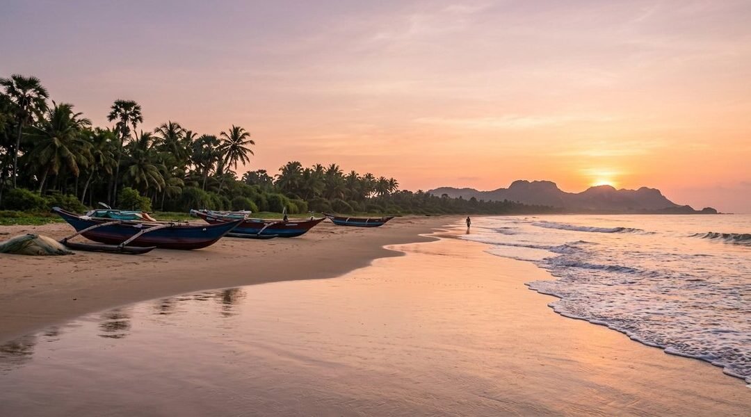
There’s a point in every Sri Lanka journey when the roads thin out, the crowds vanish, and the ocean starts to feel like it belongs only to you. For me, that moment arrived somewhere past the last busy junction, when the tarmac gave way to dust, salt hung in the air, and the Indian Ocean appeared—wild, empty, and unapologetically untamed.
This is Panama and Okanda, two remote coastal villages on Sri Lanka’s east coast that don’t beg for attention. They don’t advertise themselves with beach clubs or neon signs. They simply exist—quiet, sunburnt, and breathtakingly raw.
If Sri Lanka’s south coast is a polished postcard, Panama and Okanda are the pages of a travel journal that still smell like sea spray.
First Impressions: Where the Map Feels Optional
Panama sits just south of the more familiar surf town of Arugam Bay, while Okanda lies even further south, skirting the edge of Yala East National Park. This stretch of coastline feels like the country exhaling after holding its breath.
The beaches are long and uninterrupted. Fishing boats rest on the sand like they’ve been paused mid-story. Palmyrah trees lean toward the sea. And the silence—broken only by waves and wind—feels deliberate.
I remember standing on the shore at Okanda at sunrise, realizing there were no footprints in the sand except my own. No vendors. No music. Just ocean, sky, and time moving slowly.
Panama Beach: Laid-Back, Local, and Beautifully Unpolished
Panama village has a gentle rhythm. It’s not sleepy—it’s simply unhurried.
What to See in Panama
Panama Beach
Wide, sandy, and often empty, this beach feels personal. The waves roll in with confidence, and the shoreline stretches far enough that walking it feels meditative.
Lagoon Backdrops
Just inland, you’ll find lagoons and wetlands reflecting the sky, especially stunning in the early morning when birds rule the airspace.
Fishing Life
Watching fishermen bring in their catch at dawn is its own quiet spectacle. No performance, no audience—just daily life continuing as it always has.
What to Do in Panama
Surf Without the Scene
The waves here attract surfers who prefer solitude over surf schools. It’s surfing stripped back to its essentials.
Beach Walks That Go Nowhere (In the Best Way)
No destinations, no checkpoints—just walk until you feel like turning around.
Stargazing
With almost no light pollution, nights here reveal a sky that feels impossibly large.
Okanda: Where the Road Ends and the Wild Begins
Okanda feels like the edge of something—civilization, perhaps, or routine.
This is a place shaped by pilgrimage, wilderness, and the ocean. It’s also one of the last coastal villages before the landscape becomes deeply untamed.
What Makes Okanda Special
Okanda Murugan Temple
A sacred site for pilgrims traveling on foot along the coast. The temple adds a spiritual gravity to the area, especially during early morning prayers.
Proximity to Yala East
Okanda sits near the boundary of Yala’s lesser-visited eastern side. Elephants, peacocks, and deer don’t respect invisible borders—and that’s part of the magic.
Endless, Empty Beach
This is the kind of beach where you instinctively lower your voice. Not out of fear—but respect.
What to Do in Okanda
Sunrise Watching
The sun rises directly over the ocean here, painting the sky in colors that feel unreal.
Quiet Exploration
Wander the village paths, observe daily life, and let curiosity—not itineraries—lead.
Disconnect Completely
Okanda isn’t interested in constant connectivity. And after a day here, neither was I.
Getting There from Katunayake International Airport
Reaching Panama and Okanda is part of the experience. This isn’t a hop-on, hop-off destination—and that’s exactly why it remains special.
Option 1: Private Car or Taxi
From the airport, the journey takes you across the island—from the west coast, through central landscapes, and down toward the east. It’s the most comfortable and flexible option, especially if you want to stop along the way.
The scenery changes dramatically as you travel—urban sprawl fades into paddy fields, then forests, then open coastal plains.
Option 2: Train + Road Combo
Travel from the airport to Colombo Fort
Take a train toward Batticaloa or Ella
From a major stop like Monaragala or Pottuvil, continue by tuk-tuk or local vehicle
This option is slower but deeply rewarding, offering a window into everyday Sri Lankan life.
Option 3: Bus for the Adventurous
Long-distance buses run from Colombo toward Pottuvil and Panama. From Panama, Okanda is accessible via rugged coastal roads, best navigated by tuk-tuk or 4WD vehicles.
Expect dust, bumps, and unforgettable views.
Where to Stay: Simple, Comfortable, and Close to Nature
Accommodation in Panama and Okanda reflects the spirit of the place—low-key and thoughtfully minimal.
Panama Stays
Eco Lodges tucked among trees, offering open spaces and ocean sounds as your alarm clock
Small Guesthouses run by local families, where evenings often end with shared stories and home-cooked meals
Okanda Stays
Basic Beach Cabins designed for travelers who value location over luxury
Nature Retreats near the forest edge, where wildlife sightings aren’t scheduled—they just happen
If you prefer more amenities, nearby Arugam Bay offers additional options while still allowing easy day trips south.
What to Pack (and What to Leave Behind)
Bring:
Light clothing for heat and humidity.
A good hat and sunscreen.
Reusable water bottle.
Curiosity and patience.
Leave behind:
Rigid schedules.
Expectations of nightlife.
The need to always be “doing something”.
These beaches reward stillness.
Best Time to Visit
The east coast shines when the rest of the island is drenched. Sunny days, calm seas, and open skies make this region especially inviting during its peak season.
Mornings and evenings are magical—soft light, cooler air, and a sense that the world is briefly holding its breath.
Why Panama & Okanda Stayed With Me
Some places impress you.
Others change your pace.
Panama and Okanda did the latter.
Here, I stopped checking the time. I started measuring days by tides and sunsets. Conversations felt unforced. Meals tasted better. Sleep came easier.
These beaches don’t try to entertain you—they invite you to listen.
And once you do, it’s hard to forget the sound of waves crashing on an empty shore, with no one around to witness it but you.
If you’re searching for Sri Lanka beyond the brochures—where the island feels ancient, spacious, and beautifully indifferent to tourism—Panama and Okanda are waiting